CARTOGRAphy

Cartography, the art of drawing maps or geographical charts, involves a complex series of processes in which the surveyor, the cartographer, the draftsman, the engraver and the printer, or technological mediators -such as satellite observatories and computers-, intervene. the aims of the topographic survey of a precise terrain for its later inscription in a sketch. This practice, whose origins date back to prehistory, has witnessed the fantasies, discoveries and conquests that forged the various conceptions of the world that humanity produced over the centuries, and is currently being projected, with renewed techniques and scientific instruments. , towards a future of still uncertain dimensions: space.
THE MAPS
According to the information they provide, the maps - a word derived from Latin that means "handkerchief" or "napkin", including the cloth on which they were drawn - can be political, physical, meteorological, geological, ethnological, linguistic, historical, statistical, nautical. , hydrographic or military. The celestial maps - or of the constellations - are called astronomical, as well as those that serve air navigation are called aeronautical charts. Product of the conventional representation that results from projecting, generally on a plane and on a reduced scale, all or part of the spherical surface of the Earth, the maps indicate the relative extension and the position of the physical features of a determined area by means of profiles , outlines, symbols and names. Among all the documents known about the origin of human culture, maps were the first to collect news about the inhabited world, and it can even be said that history began to be "written" in them, since today specialists recognize that the making of maps preceded any type of writing. Among the oldest surviving testimonies, the maps of the natives of the Marshall Islands stand out for their careful production both in terms of geographic accuracy and craftsmanship. For their part, the Colombian Indians surprised the Spanish conquerors with their maps drawn on tree bark that, rolled up, they carried with them on their journeys, and in which they wrote down the names of the rivers and mountains of the region. The Eskimos, Aztecs, Maori, and Malays, to name just a few, also made maps, albeit more rudimentary, in stone, wood, and bone.
Birth of cartography
The oldest map of humanity is a cuneiform tablet found last century near the ruins of Babylon, which is preserved in the Semitic Museum of Harvard University. This fired clay tablet, engraved in cuneiform characters, dates from about 3,900 BC. It shows Mesopotamia, surrounded by mountains, crossed by the Euphrates River. The cardinal points are indicated by small circles, which shows the degree of precociousness of the Sumerians in the field of astronomy. On the other hand, the Sumerian conception of the Earth as an inverted round boat floating on the waters inspired the first Greek cartographers. The first map in which "the entire area of the Earth was represented, with all the seas and all the rivers" was attributed to Anaximander of Miletus.
ARGENTINE CENTER OF CARTOGRAPHY
The Argentine Center for Cartography was created on November 23, 1955, with the aim of forming an institution where technicians and professionals who were dedicated to this activity could gather and for its development and progress. Until then, lacking antecedents in the country, its creation was going to allow Cartography to assume the role that corresponded to it, within the technical-scientific task at the national level. Its main objectives include the following: Creation of a National School of Cartography. Delivery of diplomas or certificates of suitability to those technicians lacking them. Honorary member recognition through diplomas, to all those professionals and technicians who had excelled in the exercise of this activity. Conducting courses and conferences. Stimulus to promote the preparation of works on Cartography. Creation of the Cartography Day, etc. It should be noted that all these objectives were achieved.
GEOGRAPHIC MILITARY INSTITUTE
Its origin is identified with the birth of the Military Topographic Office, which occurred on December 5, 1879. At the beginning of 1901, it adopted the name of Military Geographical Institute that continues to this day. His achievements affirm the importance of the specialty and in 1919 the national government assigned him the responsibility of raising the chart and geodetic works to support civil, as well as military activity. The need for a Charter Law was beginning to emerge. With the promulgation of the "Law of the Charter", on October 3, 1941, began in a systematic and regular way, the realization of fundamental geodetic works and topographic surveys with uniform and homogeneous support throughout the national territory. The IGM is a decentralized body that operates within the scope of the Ministry of Defense. According to Administrative Decision 520/96, it is assigned as primary responsibility, understanding in the planning, programming, execution, control, supervision and advice of the geographic activity, at the national level, in order to satisfy the objectives and policies established by the National Executive Power, contributing to an effective definition and representation of Argentine territorial sovereignty. The work area of the IGM staff is only limited by the size of our country. Its main headquarters are located at Av. Cabildo N ° 381 of the City of Buenos Aires.
SOME USEFUL DEFINITIONS
ATLAS: Name given to the first collection of Mercator's maps, published in 1595, which had on its cover an engraving with the figure of Atlas. (In Greek mythology, for having sided with the giants against the gods, Atlas was punished by Zeus for eternally holding the celestial vault on his shoulders.) By extension, a collection of maps in book form.
WORLD MAP: Map of the Earth in two circles and ellipses, corresponding to the two hemispheres.
PLANISPHERE: Representation of the surface of the Earth in a plane.
From the Book TERRA AUSTRALIS by Carlos Pedro Vairo Ed. Zagier & Urruty 2011
Introduction
This work is closely linked to the script of the exhibition at the Maritime Museum of Ushuaia. The evolution of cartography coincides with that of the voyages of “discovery”. These produce a change not only because of the findings but that all knowledge evolves. On the one hand, the knowledge of the "Earth" and cartography, that is, geographic knowledge. This also changes the interest of the different kingdoms in acquiring greater power and becoming maritime powers that in turn dominated trade. Simultaneously, shipbuilding evolved in the face of the new needs of commerce and war. Also changes in the thinking of the population in general when it was found that the earth was round; then they continued with scientific advances to be able to locate themselves in the sea and make hydrographic surveys with greater precision. The changes were very profound, and even coming from the biological sciences, they even affected religion, such as Charles Darwin's theory of the evolution of species. As one delves into the history of discovery and voyages of exploration in the southern region, so necessary to fulfill the objective of seeking wealth in the East, questions arise such as what they were based on to venture into the unknown with such precarious means. Of course, there was a great dose of adventure and imagination, it is essential for man to advance, but also a dose of knowledge received in a trickle and from remote regions. They were not totally blind trips but they all had, although in some cases very small, a share of information produced by other travelers. Either by chance or by some storm, these travelers gave the indications for others to advance a little more, and in this way demystify theories or elaborate new ones: the myth that lasted for almost a century of a Tierra del Fuego being part of a great southern continent; or as was the exploration of Antarctica; or the search for the mythical "Peppis" islands, just to cite a few examples. The study and interpretation of ancient cartography was very rich since it complemented, with great luxury, the understanding of the vision of these explorers more deeply. The iconography that accompanies them clearly shows the concept that they mentally formed, both of the original peoples and of the wealth of the region. Also of fantasies and fears about what could happen in the face of the unknown: taking whales for sea monsters; be aware that the gigantic sea snakes or the dreaded giant squid appear (the latter case until not long ago). All this with the particularities of the evolution of cartography from parchment, handwritten copies, engraving, printing houses, cartography cabinets and art in drawing, coloring, encyclopedias, publishing houses and even economic power and political that this represented. In this way, the search for ancient cartography of the southern region developed for more than twenty years ended in a good collection that is in the archives of the Maritime Museum of Ushuaia. Initially motivated by the collection that exists in the Department of Naval Historical Studies (Casa Amarilla) but which was centralized in the region that makes up the Province of Tierra del Fuego. I should be grateful for the guidance provided by Prof. Mateo Martinic Beros from the Institute of Patagonia (University of Magallanes) and Oscar Pablo Zanola from the Museum of the End of the World; both with their particular vision, the first more centralized in the Strait of Magellan and the second in proto-cartography.
Brief history of cartography
We can say that cartography as a science has its origins in Ancient Greece, but it is noteworthy that they started from a general idea of the world similar to that of the Babylonians. To briefly locate ourselves on the subject, the Babylonians had maps around 2,300 BC, although their purpose was to collect taxes. It is also interesting to mention that before written history there were already maps. These were a necessity for all civilizations and essentially showed necessary itineraries to be able to move from one place to another or to know distances. They can be grouped into two large groups: a) those that showed a place, informative b) and the more intellectual ones that with images represented the Earth including a cosmological and religious sense, but from the author's point of view (as the center of the Land). The Egyptians had maps that were itineraries to go to different places with ethnic drawings where the towns to be found on the way appeared.
The Greeks
Returning to classical Greece and without being totally sure, it is believed that the first map that represented the known world had a circular shape; around the Aegean Sea was the known world, in turn surrounded by the Ocean Sea. This map is attributed to the Greek philosopher Anaximander in the 6th century BC. For Thales of Miletus (VI BC) the world was spherical, which he conceived by eclipses. It is possible that it was believed that the inhabited part was the upper one and in the rest was the ocean, that is to say that it rested on the water that was the origin of all wet things (such as the seeds of nature). It is as if many questions wanted to be answered with few true answers. Although there is a great evolution, we can say that current maps are based on the "mathematical geography" of classical Greece, which was perfected until the 15th century. Among these great advances is the division of the Earth into meridians and parallels (although at irregular intervals) by the philosopher Eratosthenes who was the third director of the library of Alexandria (200 BC). Among his important observations and his mathematical calculations we must attribute the first measurement of the Earth (40 thousand kilometers); as well as the distance to the sun and the moon. He calculated the ecliptic almost perfectly (23º 51´ 15 ”). In addition to a chronological history book from the Trojan War, he mapped Britain to the Ganges, as well as Libya and Yemen to the south. He already had parallels and some meridians. He collected the information that came to him from sailors and explorers. The distances were obtained by the days of navigation, which was calculated with favorable wind and a speed of 4 to 6 knots. Ptolemy was a Greek cartographer who lived between the 1st and 2nd centuries AD. He had a great influence until the Middle Ages by the reproduction of the terrestrial sphere by means of a conical projection of the cartography of him, although with great errors such as the great extension of the Eurasian region. He systematized the representation by always placing north up and calculating the coordinates. He invented instruments like the quadrant with which explorers could calculate latitude. The quadrant originated others like the astrolabe, perfecting itself until it reached the sextant. During the Roman Empire two types of maps were distinguished: a) the world maps of great beauty and b) the Itineraries, which would be followed by armies, merchants and other travelers. After the fall of the Roman Empire there is a great regression in the cultural aspect and, based on aspects of the Bible, there is a return to the idea of a flat earth with beautiful illustrations that turn them into true works of art. But mathematical geography and coordinates were put aside, the great advance of the Greeks. It was the Arabs who took back the knowledge of Greece and made maps extending its borders (8th to 9th centuries) and thus re-entered the West. The great figure will be Al-Idrisi, who used the work of Ptolemy as the main source and made a map of the world in 1154. Only when trade with the East was closed, Spain and Portugal felt the need to explore and leaving theological aside began to capture the knowledge of sailors.
Portulan
Nautical charts (navigational maps) appear that originate in the instruction notebooks where sailors wrote down the direction and distance between ports. They had their apogee from the thirteenth century to the beginning of the seventeenth. These letters crisscrossed by a network of black lines marked the routes to the ports of departure and arrival. The lines were related to the predominant local winds that were taken among the eight most important (Levante, from the East; Tramontana, from the North; Greco, from the NE; Siroco, from the SE; South or South, from the South; Lebeche, from the SW; Poniente, from the West; Mistral, from the Northwest; such as those of the Mediterranean where the Portulano originated). One of the main characteristics is that only the coasts were drawn with relative accuracy. The obstacles encountered by sailors such as islands, reefs, shallow depths, etc., were also being added. Of course, in addition to the maps used by navigators, others were made for princes and kings where the most important artists and cartographers intervened. These nautical charts (portulans) were made on parchment and were constantly perfected since by scraping the parchment it could be erased and redrawn. Especially when the use of the compass became more frequent, at the end of the 13th century, and also the astrolabe (of the quadrant) to know the meridian, that is, the position of the navigator (observer) at noon (when the sun was highest ). Although they did not have coordinates, they maintained a linear scale and from there the distance between ports could be obtained in "sea" leagues. Due to the material in which they were made, the shipwrecks and the fact that they were made to order, not many have survived. The most famous are: the Carta Pisana, the Portulano by Angelino Dulcert where the Canary Islands are represented for the first time, and the Catalan Atlas by Abraham Cresques. How the "dark" times of the West will have been lived that these Portulans coexisted with the "Flat Earth" maps of the monasteries, based on the knowledge of theologians. This is how it was only in the 15th century that Ptolemy's discoveries resurfaced. Only thirteen centuries later, the West takes up the knowledge developed by the Greek philosophers. These techniques allowed for better surveys just as the great voyages of exploration began. In a secret way the most daring "rediscovered" the roundness of the Earth, much in spite of the "monastics". In this way the Portulans were combined with the teachings of the famous Ptolemaic letters, which survived until 1600. In the Renaissance, cartographic development was very important. Mercartor and Ortelius put an end to the Ptolemaic letters (mid-16th century). At this point we will suspend a little the general history of cartography and then enter the particular one of America and Tierra del Fuego. Both Solís, Pinzón, Juan de la Cosa and Vespucio (hired by Felipe II) contributed with their expeditions to the drawing of the first known maps of the American continent. Likewise, the so-called Salviatti and Castiglione planispheres, both from about 1525, are important cartographic documents from the time on which later maps were based. The Castiglione planisphere was gifted to him by Emperor Charles V. Martin Waldseemüller's map (made in 1507 and printed on 12 separate sheets) was one of the first in which North America and South America were clearly separated from Asia. This German geographer was the first to designate the newly discovered lands as America. Apparently the name was in recognition of the work of Américo Vespucio, who worked for the Lusitanian crown, although no data is found on him or in the archives. This is as an example of how much information, be it travel diaries and nautical charts (maps), was lost due to looting, fires and other catastrophes. But as for the drawing of the maps, it was done with Portulanos and the Ptolemaic charts. Christopher Columbus relied on this type of knowledge and cartography to try to reach the East by crossing the Atlantic. This is how many defend the actions of Américo Vespucio and approve of calling the continent America, although others say it should have been called Colombia. Abraham Ortelius, Flemish, was the one who published the first Atlas in 1570. It was reprinted with corrections until 1612. His work "Theatrum Orbis Terrarum" in its first version contained 70 maps: 56 of Europe, 10 of Asia and Africa and one of each continent. He made a selection of the best available maps that he redrew with a uniform format and established a logical order of the maps: world map, Europe, Asia, Africa, New World.
He also included a list with the names of the authors of the maps. This atlas was very successful, especially because of its size and format. It was edited in various languages. Although the discoveries were kept in the greatest secret since there was a lot of espionage, he was nourished by the stories of the Portuguese explorers when he was appointed court cartographer by Felipe II. Gerhardus Mercator (1512-1594, German-Dutch) made a great innovation. In 1569 he edited a world map where he used a rectangular cylindrical projection, as we know it today, where the whole world is without the poles. Parallels and meridians are represented at regular intervals and although they deform when the poles are reached, they are still used today to navigate (logically with all the corrections that technology has allowed). It has many virtues for navigation such as loxodromia, angles for each meridian, which can be obtained by graphic means. The first year after Mercator's death his great book of world maps was published. He named it Atlas, in honor of the giant of Greek mythology that supported the celestial vault, and since then the major works of cartography have been named. Later, the famous copper engravers Jodocus and Hondius refined and republished Mercator's atlas. As an illustrative data, cartography was also developed in the Mayan and Inca civilizations. The Incas, in the 12th century AD, made maps of the lands that were attached to their Empire.
Inv. No. 62 MMU. "Orbis Veteris Descriptio seu Ptolemaei Typus". Made by Giovani Antonio Mangini. Published in 1713. Ptolemaic projection. Actually successive publications were made of this map which was first published in 1595 (circa). Describe the Ancient World and sketch a closed Indian Ocean. It is interesting as an example of this projection to compare with the Mercator, which was later adopted and is the one currently used.

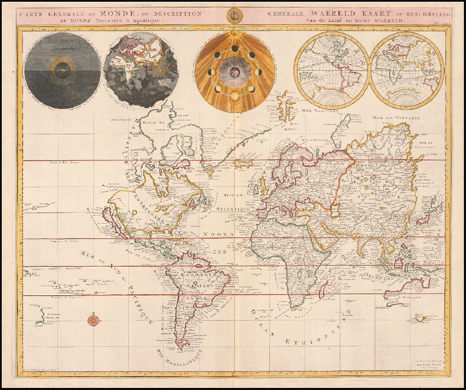
Inv. No. 100 MMU. World map made by Pierre Mortier in 1700 (circa). “Carte Generale du Monde, ou Description du Monde Terrestre & Aquatique”. It is the first map drawn in Mercator projection. California is listed as an island. The “mer de Paraguay” appears near the mouth of the Rio de la Plata. The legend "Magallanique" is distinguished in Tierra del Fuego and in Patagonia with a northern border in Cabo San Antonio (approx.). You can see five spheres in the upper part: night and day; the tides; the phases of the moon; the western and eastern hemisphere.
Cartography in the 15th century
We will describe what the situation was in Spain. We have already seen the advances in mathematical geography and navigations that were driven by the closure of the eastern market on known routes. For this we will refer to the Casa de Contratación de Sevilla and its role in geographic knowledge through nautical cartography. In 1503 this institution was created, which is what today we would call a kind of Secretariat for Maritime Issues, which depended directly on the King of Spain. At first he dealt with all overseas affairs. He had responsibility for everything that was related to commercial and conquest affairs, to new discoveries and what this entailed. Over time, everything related to the New World and then the lands discovered in the South Sea (Pacific) were added.
One of his functions was to teach and examine "the arts of deep sea navigation" (it was a bit of common sense, experience, tradition, and a bit of science) to expedition pilots. Also something that was very important: the compilation of all the geographical news reported by the navigators, which allowed the elaboration of more truthful nautical charts. For this he made it mandatory that a diary be kept, which was sometimes a simple account, of what happened in the navigation and what was sighted. To put order in the chaos of lands that each navigator located in different places, the Chief Pilot Américo Vespucio (Amerigo Vespucci) was ordered (in 1508) to gather all the pilots and make a "pattern" of the discovered lands, thus making the Real Register. It focused on the lands belonging to the Spanish crown. He also ordered that the pilots should be guided only by this Register and report all the news they find. In 1527 it was more express, ordering that the pilots should write day by day the entire trip from whatever port to their arrival in Seville or Santo Domingo, clarifying the path they made, the course, the lowlands, islands, distance from the coast. , and everything related to navigation. Faced with the great work that the Senior Pilot was subjected to, his activity unfolded. He was left with the responsibility of teaching and examining the pilots, while the "cosmographer" appeared, who made the navigation instruments, the nautical charts and the Royal Register. All this is of great importance because it takes place between 1518 and 1537, where the first charts from South America appear, from the Strait of Magellan, and an “Incognita Australis Land” is hinted at, which for many could be the Antarctic continent (to which we will dedicate ourselves more depth). It is at this moment that we see a transition that we can notice in the nautical charts published in this work. The "Ptolemaic" resolution (rectangular conical projection) was no longer used to move to a square chart where the degrees of longitude and latitude appear, and later the depths. But some spider knots and compass roses remained, more as a stylistic aftertaste than anything else. It is important to note that the distance of 17 1/2 leagues per degree was used. Although not all used the same measure, which caused a lot of confusion and subsequent confusion when trying to interpret the navigations of the different expeditions: they depended on the league used and how much the degree measured. The aforementioned measure was with Castilian leagues, but the degree in German leagues was 15. And also how much was a league: it could be the legal 3 miles or the common 4 miles; and in turn, the mile used at that time was 1,480 meters (one thousand steps) and not the nautical mile of 1,852 (see the book Cartography and Navigation by Rubén Álvarez, Enrique Albornoz and José María Olivero, a very good work for those who want to deepen). A clear example given in this work is the reference to the Nao Santiago, which in 1520 entered more than 20 leagues through the Uruguay River. From what latitude? What league? The nautical charts made on parchment by the Seville Contracting House, as well as the Royal Register, were made only for the pilots who needed them on their trips to the New World. It was considered confidential and strategic material. Especially when corsair activity and piracy became more important. Either way the information leaked, and letters from the Strait of Magellan and South America quickly circulated throughout Europe. Espionage, like intrigues, was everywhere. As an example, Francis Drake prohibited any of his crew from drawing maps or taking notes. Nothing done in the circumnavigation of 1577-1580 was officially known either, but his nephew John Drake's followed his own course. There are many verified cases of espionage and copies, such as the "Carta Cantino" of 1502, known by the name who commissioned it and not by the Lusitanian who copied it. It is found in a library in Modena, where the letters from Christopher Columbus went. Some were copied? Those of Sebastián Gaboto?

Inv. No. 44 MMU. At that time, at the beginning of the Age of Discovery, many ships left and did not return. Those who returned related their encounter with large fish that threw water, becoming part of a great series of sea monsters that they blamed for so many disappearances. In Sebastián Munster's 1550 plate we see some of them represented, based on the stories of the sailors and the imagination of the cartoonists. Each letter corresponds to a description, and its danger that is detailed in Annex 1 ("Monsters ..." of "Cosmographia", of the city of Basel). A caravel is seen in one scene throwing barrels of food while trying to calm a monster (whale) by blowing trumpets. We also see snakes that, according to the beliefs of the sailors of that time, made ships knock down. At the top is the terrestrial world with animals known as bears and deer, among others.
The Strait of Magellan
Going back a bit in history we are going to deal more specifically with the Strait of Magellan, which on the other hand are the first nautical charts that reflect a small part of Tierra del Fuego. The project of the Portuguese Hernán de Magallanes was studied after several attempts to find a passage from one sea to another. Among them was that of the discoverer of the Río de la Plata Juan Díaz de Solís. He was appointed Major Pilot of Castile on the death of the famous Americo Vespucci (February 1512). In this way he became Admiral of the Spanish Discovery Fleet. In October 1515, after successfully circumventing the attempted sabotage of the Portuguese crown, he set sail from the port of Sanlucár de Barrameda and touched the coast of Brazil, then coasting Uruguay, and entered a great sea of "low Salinity" that he called Mar Sweet (it is about the Río de la Plata). On the eastern coast, off Martín García Island, he found death at the hands of the aborigines and his crew decided to return to Spain on September 4, 1516. He made a sketch of the coasts to the Río de la Plata that served for the scans that happened to him. Previously (1508) he had been sailing with Vicente Yañez Pinzón through the Caribbean area and the Florida coast, apparently looking for a route to the Spice Islands. Thus it was that Hernán de Magallanes got his project approved and obtained royal authorization to explore the coasts, but sailing south in search of a passage. It is important to understand that at the beginning of this "Age of Discovery" you had to have the authorization of the crown to build a fleet (this does not mean that there were no clandestine explorations). From 1517 he began to prepare the squadron and set sail on September 20, 1519 from the port of Seville. Thus begins the most important exploratory adventure in the world. He arrives in America, passes through the "Mar Dulce" (Río de la Plata) where he investigates a little more with the data he had on Juan Díaz de Solís, and continues south. After several storms and breakages in the ships, he arrived at Puerto Deseado (which he called Bahía de los Trabajos Forzosos, for the repair tasks) and then wintered in San Julián. This happened on March 31, the eve of Palm Sunday. Summer gave way to winter that punished the fleet. It is there when Hernán dev Magallanes announced that the fleet would remain in place until the weather allowed them to resume their exploration in search of the pass. He stayed in the mooring for almost five months. In that period of time he sent Santiago to explore the coast, but this ship did not return. Wintering was not entirely pleasant, since in addition to the novelties that Patagonia had in store for him, he had problems with his captains and a rather inhospitable climate. The Captain General decided that it was prudent to anchor his flagship at the mouth of the bay: in this way he closed the entrance and any ship that tried to pass was within range of his guns. That was the climate that prevailed in a desolate place with very sparse vegetation, flanked by cliffs, where the tide has an amplitude close to 8 meters and the speed is approximately 6 knots in the narrow mouth of half a mile wide. On October 18, 1520, he set sail again south after landing at the Santa Cruz estuary. After three days, and very secure in his theory, he doubles a rope. Because it was the day of Saint Ursula, who was converted into a martyr along with eleven thousand other Virgins, he calls it the Cape of the Eleven Thousand Virgins (today Cape Virgins). Thus begins a long exploration with many setbacks and defections. By that time, the Caravel Santiago had been lost, near the mouth of the Santa Cruz River (to the south). This is how Trinidad, San Antonio, Concepción and Victoria entered. The whole epic of crossing the strait that today bears his name is worthy of “men of steel in wooden boats”. La San Antonio and La Concepción avoid the first strait and when they see seawater up to the horizon and great depths, they are convinced that this may be the much sought after passage. On a stormy night the fleet anchors in a bay on the southern shore of the strait. When they see smoke, a boat comes out to explore its origin: they are obvious signs of human presence, although they do not run into any living being. The place was baptized as "Land of Smokes" and / or "Land of Fires. Then they pass the Second Angostura, and after five weeks of exploration they arrive at the sought after South Sea ("Sinus Magnus" Tolomaico), which it calls the Pacific because of how calm its waters are. We see his spirit when he leaves behind the two capes that overlook the Pacific and which he baptizes Deseado and Victoria. There are versions that the strait had already been discovered previously by private or clandestine exploration, and some argue that it was a rediscovery. Whether it is true is not known, since it has not been recorded either in history or in cartography, and certain interpretations of very old charts called "proto-cartography" are made where they claim to see Tierra del Fuego well defined. These cartographers were generally guided by the comments of the sailors, and tried to obtain as much detail as possible, which they later captured in a drawing, many times modifying existing maps. They base this belief on the interpretation of an appendix on the South Asian Continent that they believe to be America, known as the Dragon's Tail, and they also argue that Haro's fleet passed through the strait six years before Magellan's expedition.

Inv. No. 13 MMU. The "Fretum Magallanicum" is a curious vision of unknown lands, as those of the extreme south of America were for a long time. This one shows Patagonia from the Río de la Plata.
First maps of the strait
The first maps appear with the hint of the strait. One apparently arises after the arrival of the San Antonio, where there is a large bay as the beginning of the "strait", which Juan Vespucio called "Cava de Sto. Antonio ”(1523). The San Antonio, the expedition's defector ship, had passed the first narrows. There is also another map kept in the TopKapi of Istanbul under the title “Esta Terra Descobrio Fernando de Magallanes” (it is on display, although I think it must not be the original). But without a doubt the first sketch belongs to the one who later became the official narrator of Magellan's trip, that of Antonio Pigafetta. He made several manuscripts of the trip, the most interesting being the one that is preserved in the United States of North America, and in each copy there is one with slight variations, but all present a narrow rectilinear with some inflections that are the narrow ones. Antonio Pigafetta had joined the expedition more because of his adventurous spirit and the desire to see what was there; he then he would see if he would get any profit out of it. Thus faith as he wrote "Notizie del Mundo Novo con le figure del paese scoperti descritte da Antonio Pigafetta, Vincentian, Cavagliero di Rodi" of which he then he made several versions at the request of the monarchs. As a clarification, it is interesting to mention that he wrote these "memoirs" on request and they were just that and not a logbook or the trip itself. Although the first map showing the pass and the adjacent lands is from 1523, known as the “Royal Register of Turin”, made in illuminated parchment (with colors). Several maps followed until 1531 when the first one was printed (made by the Frenchman Orontius Finnaeus) but with a very important detail: to the south of the strait there appears a large mass of land covering the South Pole, which was called “Terra Australis Recenter Invents sed nondun full cognita ”, later synthesized for more than a century as“ Terra Australis Incognita ”. In 1540 in the Islario de todos los Islas del Mundo (by Alonso de Santa Cruz, cosmographer of the Casa de Contratación de Sevilla) a particular chart of the strait appears incorporating the information from the Loayza and Camargo explorations (See map Inv. No. 27 MMU).
Secret about what was discovered and clandestine expeditions
At that time it was speculated that the "pass" navigated by Hernán de Magallanes (Fernando de Magalhais), when attempts to find it failed, had been closed due to some natural catastrophe. A half dozen clandestine expeditions are also known, without royal authorization, but they are somewhat vague references and without much contribution. It is to be considered that if they obtained information it was for their own benefit, although it was not reflected in the history which was the same, nor its subsequent use. The Spanish crown tried to keep the greatest secret on the subject. This is how other nations prepared to find such a pass, or any that would allow them to reach the "Spice Lands."

Inv. No. 75 MMU. Illustration of the voyage of Dumont D´Urville 1846. “Voyage au Pole Sud et dans L´Oceanie”. Strait of Magellan-. "Entree des forets de la rivier Sedger"
It is interesting to see what happened to a survey expedition to the Strait of Magellan that was carried out in the Pacific and lasted several years. From 1540, Captain Pedro de Valdivia wanted to conquer the territories to the south of Peru to the Strait of Magellan. He asks the king to grant him these concessions and simultaneously sets out an expedition. Under the command of Francisco de Ulloa, in October 1553, three ships left for the unknown south. As soon as they passed the Gulf of Penas, they encountered the intricate archipelago and steep coasts of the area, accompanied by a very harsh, almost inhospitable climate. The three ships separate and go through the area in search of a western access to the Strait of Magellan. Only one reaches the eastern mouth of the strait, that of Captain Hernando Gallego, then returning to Valdivia in January 1554.
Once these results are known, the new governor orders the expedition of three ships under the command of Captain Juan de Ladrillero in November 1557. Returning to Valdivia in March 1559, he carried out a work that was reflected in the Description and Route of the Strait of Magellan; which duplicated, at least, the information we had about him. The Casa de Contratación de Sevilla, seeing such valuable information and with fear that it would fall into enemy hands, kept it secret for more than two and a half centuries. It only transpired what the vision of the south west coast was like. Until 1800 it was stored, or perhaps lost, among papers and letters from hundreds of other pilots. It was only then that many of Ladrillero's explorations were turned to cartography. This expedition was followed by that of the English privateer Francis Drake, who in 1578 entered the strait with four ships. He crossed it in only sixteen days, but after that relative tranquility he had months of bad weather that led him to the south, discovering that there was no continent as claimed at that time. With so much storm, it is not very well known his journey or where he found refuge to take a break and repair the ship. Francis Drake continued his journey harassing the coasts of South America with the Golden Hind, later managing to complete the second round the world tour. This is how that Sea was called "Mar de Hoces" by Spain and "Pasaje de Drake" by the Anglo-Saxons. In addition to the geographical discovery of him, he managed to demonstrate how vulnerable the Spanish crown was with its dominions in America and the passage through the strait. This greatly disturbed the Spaniards, and they even thought of closing the strait with chains to prevent the passage of ships of other flags.
The reaction was almost immediate. On January 21, 1580, Sarmiento de Gamboa arrived, leaving from Valdivia to the south, carrying out a survey and investigating the possible presence of foreign flags in the area. He finishes his work at the end of February and continues to travel directly to Spain to be able to give an account of what was explored to the royal house. His work was very good and complemented that of Ladrillero. Unfortunately they suffered the same fate: they were jealously guarded; and in a way they were not surpassed until two hundred and fifty years later with the English expeditions. The second trip of Sarmiento de Gamboa in 1583 had the objective of founding two cities with the intention of populating the region and in a way defending the “strait”. The result was quite regrettable, since practically all perished while waiting for the reinforcement ships with food and other equipment to maintain the populations.

Inv. No. 47 MMU. Port Desire. By Le Maire, 1619. The expeditions on their journey to the Strait of Magellan, or when they were rejected by it, sought refuge in Puerto Deseado. Either to spend the winter or carry drinking water and fresh food, such as meat from penguins, sea lions, guanacos and rheas. He was baptized by the navigator Cavendish on December 17, 1586 when he landed with his flagship Desire. In the picture we see when the Hoorn of Schouten and Le Maire's expedition is set on fire. The English privateer Thomas Cavendish, with three ships, entered the Strait in February 1587 and found some survivors in the place that he called Port Famine (Hunger Port), in what was the City of King Don Felipe. He embarks only one of the Spaniards, leaving a group of twenty to his fate, although he does remove the four cannon batteries left by the Spaniards. He continues his journey to California setting fire to three cities and seizing thirteen ships, thus filling his holds with Spanish (American) silver and gold. He crossed the Pacific and completed the third round the world when in September 1588 he arrived in England. Corsair trips continued, giving England knowledge of the area. On several occasions they captured Spanish pilots who had more geographical knowledge. Thus happened the expedition of John Childley (1589) that ended up in Port Famine, but without being able to complete the crossing of the Strait, he returned to England with the last Spanish survivor of the Gamboa expedition. Then followed another by Thomas Cavendish (1591). Luck was not with him. They reached the strait, but storms and a harsh winter forced them to return. John Davis, captain of one of the ships, after suffering a thousand inconveniences decided to return to Europe and described some islands that apparently were now known as Malvinas (this is found in a story by John Jane). In January 1594, Captain Richard Hawkins's fleet arrived in the Strait. He made an important contribution by exploring the southern bank, discovering that it was not a large land mass but an intricate archipelago. He also sailed through the Malvinas Islands. He recounted his experiences crossing the strait to reach the South Sea and his captivity in Peru in the book The Observations of Sir Richard Hawkins in his Voyage into the South Sea, after returning in 1602. All these voyages left a very positive balance for the geographical knowledge of Great Britain and a notable weakening of Spain.

Inv. No. 41 MMU. Published in 1598, this Munster / Petri World Map shows us the “New World”. It must have been drawn by Munster before 1552 (he passed away that year). Among the peculiarities it has, it shows a passage to the north (northeast and northwest), which was rediscovered centuries later. In the south a great continent "Terra Australis non Cognita". It is separated from the American continent by the "Strait of Magellan". This was the view of the world in the late 1500s. Hawkins' expedition was officially Britain's last; only buccaneers or pirates followed. The attention of the English crown turned to North America and the East Indies, but passing through the Cape of Good Hope. Thus they built the famous British Empire. Before Francis Drake's journey, the interest to settle in the Strait of Magellan or even in Patagonia was evident. Richard Grenville presented Queen Isabel with a project to establish settlements in the lands south of the Río de la Plata and Chile. According to his project, these lands were unoccupied, with great possibilities of contributing treasures for the crown; It is what we currently know as Patagonia. But since the relations between the two crowns were very good, it was only resumed years later (1577) by Francis Drake whose intention was to reach Peru and completed the circumnavigation due to the poor conditions encountered when passing through the Strait of Magellan. It is due to the geographer Richard Hakluyt who in 1589 compiled and published reports of the voyages in Principal Navigations. He did not limit himself only to the story but also to the log, sketches and itineraries of both the English sailors and those they could get from other flags. Sixty-four navigations concerning the New World appeared in this first publication. In 1600 he published it again, but with more than a hundred narratives including the battle with the Invincible Armada, the trips to Guyana and the first ones to Asia. He is succeeded by the geographer Samuel Purchas (also religious). It should be noted that it was difficult for them to find information on South America, especially the Pacific coast, given the prohibition of its publication by the Casa de Contratación de Sevilla. Also notable is Hakluyt's 1580 publication of the importance of the British occupation of the "strait" in his 1580 book A Discurse of the Commoditie of the taking of the Strait of Magellan. He argued that the Strait of Magellan was the key to dominating the East and West Indies. He managed to publish even that of Sebastián Gaboto in his survey of the Río de la Plata, made known to the English reader what the New World was like and created the travel and expedition literature with which England became so famous. Purchas also incorporated Africa, Asia, North America and the Caribbean. As a small note on these editions, the knowledge about the treatment applied to the Indians by the Spaniards stands out when extracts of the father Fray Bartolomé de Las Casas are published; Of course, being anti-Spanish, these were highly subjective writings, but ultimately they were the ones that formed the opinion and knowledge of English-language readers. To continue with the English, even if we then go back in time to deal with the Dutch, in 1669 Narborough and Wood made a commercial trip to the coast of Chile. The mission consisted of trading with the natives of the place without coming into contact with the Spanish. They were trying to get to the source of wealth. These instructions were given for everything they traveled south of the Río de la Plata.The result, commercially poor given the resistance of the rulers, had great repercussion due to the important survey carried out in the "Strait", which was reflected in handwritten and later printed maps. In 1694 an account of the trip was published: An Account of Several Late Voyages & Discoveries, which was, for a long time, the bedside book of the area. The result of the two and a half months that he spent in the "strait" between the outward and return journey. Among the points where he landed and carried out important studies we have Puerto Famine or Punta Arenosa (Sandy Point or Punta Arenas) in addition to the Inglés and Tortuoso passes. It was a work that covered hydrographic, geographic, climatological and ethnographic topics. In 1689, John Strong's expedition set sail for the Chilean coast. Although at that time England and Spain were allies against Louis XIV of France, the intention was to trade. With a marque certificate, apparently to disguise, the covert intentions were different. From capturing treasures from their allies to trying to establish a settlement in the Juan Fernández Islands in case they cease to be partners in the future. Although an account of the trip was written with his observations, it went almost unnoticed. The eyes of the navigators were on the passage through Cape Horn avoiding the hardships of the Strait of Magellan. This is how, when relations between Spain and England were broken, a great expedition was sent to the Pacific (1740). It was the one led by George Anson, whose instruction was to take every enemy ship and attack and set fire to the Spanish settlements, especially Lima, Callao and Panama. He had to try to convince the natives of the area to rise up against Spanish authority and the advisability of dealing directly with the British crown. After this expedition, British interest was in Asia, North America and the Caribbean, always trying to prevent the French from entering. It was not until 1806, under the orders of Robin Crauford, that a fleet of four thousand men was sent to take Valparaíso, cross the Andes, and rejoin the troops that had taken Buenos Aires. This did not happen given the resistance of the population of Buenos Aires, but it shows the true interest in taking over the southern region of America. It is the aforementioned Hakluyt project. When they were rejected for the second time in the attempt to invade Buenos Aires, in 1833 they took the Malvinas Islands and thus managed to possess "the key to the entire Pacific Ocean"; according to statements by the Admiralty. In this way they could dominate the passage through the Strait of Magellan, Cape Horn and the landfall for the latest discovery: the South Shetland Islands and the Antarctic Peninsula with their wealth of sea lions and whales. It is noteworthy that North American and English wolf ships sought refuge on the islands since 1770. Meanwhile Luis Vernet, Argentine governor of the islands, protested and tried to expel them.

Inv. No. 50 MMU. Also from Lord Byron's trip we get this picture (1778, published by A. Hoog and Hamilton Moore) of his meeting with the Patagonians where we see him with a woman with his child. He presents the woman with a necklace and a beaded bracelet.