geography of TIERRA DEL FUEGO

USHUAIA

It is the capital of Tierra del Fuego, being the only Argentine city "on the other side of the Cordillera", it extends along the coast of the Beagle Channel, between the Olivia rivers to the east and Pipo to the west, with the Martial mountain chain behind their backs.
Ushuaia is a tourist city for its imposing landscapes, with a natural deep-water port, the closest to Antarctica, with beautiful completely virgin places just minutes from the urban center.It is truly picturesque, for its old wooden houses and metal sheet with roofs of marked slope, to avoid the accumulation of snow. On its main street, San Martín, parallel to the canal coast, elegant shops offer imported items to the increasingly large number of visitors, making it "the southernmost city in the world." When you walk along the coast or sail on an excursion up the Beagle, you will understand the meaning of the indigenous voice that is the name of the city: USH means "in the background" and WUAIA is "bay, cove or port". Or "bay penetrating to the west".
POLITICAL DIVISION
The Fuegian archipelago belongs to two countries: Argentina and Chile. In addition, each country has its own internal political divisions, subdivided into departments, jurisdictions, communes, etc. But in itself we can say that it is located between the parallels 52 ° and 56 ° of South latitude and the 63 ° and 73 ° of West longitude of Greenwich. The total area is approximately 65,000 square km, of which 20,898 km2 are Argentine and the rest corresponds to Chile. Comparing the area it occupies, we could say that its size is around 3/4 of Ireland.
The Argentine part results in an area somewhat smaller than El Salvador and the Chilean one a little larger than the area of Switzerland. The latitude of the area would correspond, in the northern hemisphere, to that of the cities of London, Amsterdam, Bruges, Warsaw, Berlin, Hamburg or Copenhagen just to name a few; although the climate of the region is totally different.
The division of the territory between both countries is given by the meridian 68 ° 40 'West of Greenwich and the line of greatest depth of the Beagle and Moat channels. Belonging the eastern part to the Republic of Argentina and the western to the Republic of Chile.
The islands south of the Beagle and from Isla Nueva to Cape Horn belong to Chile, without projection towards the Atlantic Ocean, as was definitively specified in the treaty of peace and friendship signed on January 2, 1985, in Rome. The two countries in turn divide the archipelago in different ways. For Argentina, the Province of Tierra del Fuego covers as territory the part of the Isla Grande de Tierra del Fuego that corresponds to it, the Island of the States, the islands and islets that surround it and that corresponds to it in the Beagle, the Malvinas Islands , Georgia, Orcadas, Sandwich, minor islands and the Argentine Antarctic sector. This is delimited to the south by the South Pole, to the North by the parallel of 60 ° of South latitude, to the East by the meridian of 25 ° W and to the West by the meridian of 74 ° of longitude W. The Capital of the Province is USHUAIA.
The departments that make up the province are 4: Department of Río Grande with 11,881 km2; Department of Ushuaia with 9,017 km2 (includes Isla de los Estados and the Beagle Islands); South Atlantic Islands Department with 16,932 km2 (Malvinas, Sandwich, Orcadas, Georgia and other smaller islands) and Argentine Antarctic Sector Department with 1,230,000 km2. For its part, CHILE divides the country into regions, corresponding to Region XII (Magallanes Region and Chilean Antarctica) four Provinces: Ultima Esperanza Province: Capital Puerto Natales; with the Commune of Natales, being the capital Puerto Natales and the commune of Torres del Paine. Sup. 45,830.7 km2. Magallanes Province: Capital Punta Arenas; Commune of Punta Arenas with capital Punta Arenas and three other communes. Sup. 36,994.7 km2. It is a territory on the Strait of Magellan. Province of Tierra del Fuego: Porvenir Capital; The main commune is Porvenir, this city being its capital. It has 2 other communes (Primavera and Timakuel). It covers almost the entire territory of the Isla Grande de Tierra del Fuego east of the Darwin mountain range. Sup. 29,484.7 km2. Chilean Antarctic Province: Capital Puerto Williams. It has the communes of Navarino (capital Puerto Williams) and Antarctica, its capital is Puerto Covadonga. The area is 1,382,033.5 km2 and encompasses the islands south of the Beagle and the lands west of the Darwin mountain range, as well as the Antarctic sector claimed by Chile.
BACKGROUND
The problem of the limits in the southern region dates practically from the independence of both countries.
The first "agreement of peace, friendship, commerce and navigation" (1856) agrees that the limits will be those existing in 1810. The differences had to be settled without reaching arms. Several years passed and after disputes and even some struggles, the 1881 treaty was reached where the division of the Big Island of Tierra del Fuego was established and, in an unclear way, the division of the rest of the archipelago. By then the city of Punta Arenas, on the Strait of Magellan, had already been founded. In reality it was about the transfer of the population of Fort Bulnes (1843) and its prison to a more benevolent place, choosing "Sandy Point" (1848) for it. The Argentine government embarked on the conquest of the Desert, the war with Paraguay and other internal problems left the South quite relegated. So much so that only one man exercised Argentine sovereignty in the region: Don Luis Piedra Buena; that from 1859 sailed and occupied the area. As of the 1881 treaty, the Argentine government decided to send the South Atlantic Expeditionary Division and in 1884 they established two sub-prefectures: one in San Juan de Salvamento and the other in the Bay of Ushuaia in the Beagle Channel, in front of the Anglican mission. This date is taken as the official date for the founding of the southernmost city in the world. Chile, for its part, made the first expedition to Tierra del Fuego in 1879, when Captain Montaner disembarks in Gente Grande, explores Bahía Inutil and reaches San Sebastián, returning to the continent.
The settlement in Porvenir Bay, around 1894, was already more than an establishment and several houses were erected near the port. The gold rush and the activity of the wolfhounds led to a "colonizing" current towards the southern islands of the archipelago. Thus by 1890 there were workers on islands such as Lennox, Picton, Navarino, Hoste, etc.
Although many came from the city of Punta Arenas, an obligatory port of call for all steam that sailed towards one ocean or the other, then they bought supplies in Ushuaia or Harberton, which was much closer to them. Some settled down and started cattle farms and sawmills. This is how Ushuaia became the center of commercial activity in southern Tierra del Fuego. The situation continued in this way until in 1927 the "Subdelegado de Navarino", Señor Gómez, arrived at the Santa Rosa ranch on Navarino Island, aboard the Chilean Navy ship "Cutter Porvenir".
From that moment on, a real presence of the Chilean government began, as two police officers and a nurse joined in a short time. The symbols of the Government were also placed in all the ports and the documentation that the captains of all the vessels had to present was intervened. Construction of Puerto Williams began in 1953 on the site known as Puerto Louisa. There the Federico Lawrence sawmill operated, which was expropriated by the Chilean government. The Lawrence family also had a ranch at Punta Remolino, on the north bank of the Beagle. They received logs from Almanza and Moat that were transported in rafts across the Beagle. The situation that began to reign in the area was quite confusing and after mutual claims, an arbitration objected by one of the parties and several frictions, the brink of war was reached towards the end of 1978.
The papal intervention, represented by Cardinal Samor in the mediations, avoided an armed conflict and postponed a solution to the controversy. After a plebiscite held in Argentina in 1984, the "peace and friendship" treaty between the two countries was signed. In the presence of the Pope, on January 2, 1985, the agreement was signed in Rome where Argentina lost the sovereignty of the Nueva, Picton and Lennox islands, as well as other islets and islands that were not in the discussion. In exchange for this, Argentine ships can freely sail the waters that were previously their own. On the other hand, the agreement established that for 5 years border claims could not be presented by any of the parties. This is how in 1991, continuing with its expansionist policy, Chile claims among more than 26 conflict points, part of the continental ice (glaciers of the mountain range at the height of Lake Argentino, Santa Cruz) and the area of the Laguna del Desierto inhabited by Argentines (this point went to international arbitration).
STRAIT OF MAGELLAN
With the division of the Fuegian archipelago in 1881, Tierra del Fuego Argentina only has the eastern mouth of the Strait of Magellan (Atlantic). The same treaty establishes that to the north of the Strait there is a border line, withdrawn from the coast, which runs from Punta Dúngenes (on the Atlantic) until it finds the "divortio aquarum" of the Andes Mountains. In practice, it was to leave the entire Strait of Magellan as the property of Chile, except for the mouth that faces the Atlantic.
The strip of land on the north coast of the Strait, although it was Patagonian land, was annexed with the domain of the Strait. This is how Argentina does not have territory over the Strait of Magellan, Chile owning both the coastal strip of Tierra del Fuego and the continental part.
WEATHER
The region is divided into two climatic and atmospheric zones that correspond according to their relief. In the mountainous part, bad weather almost always reigns, rainfall is abundant and the sky is permanently cloudy.
The Pampas region (North-Northeast) has a drier and colder atmosphere with a cleaner sky. The wind blows more violently and the temperature is more unstable. In general, it is a maritime climate. The body of water does not have major changes in temperature, making it more or less even throughout the year. Not too cold in winter, not too hot in summer. In similar latitudes in the northern hemisphere the situation is very different; if we take for example Hamburg or New York, with hot summers and harsh winters.
It can be said that the climate is generally very varied. The Fuegians to synthesize this fact have a saying that exemplifies it very well: "In the same day the four seasons can be presented". It is true that from a rainy and cloudy morning you can go to a warm sunny day so that after a while a shower with a sleet makes us remember where we are; and all in the course of the morning.
Temperatures
To give us an idea, let's take a look at average temperatures and their extremes. In the Northeast region the average is around 10 ° C, its extremes being 27 ° C and -16 ° C. In the Cordillera region but at sea level the annual average is about 5 ° C and the extremes are 29 ° C and -21 ° C. The coldest months are July and August, the missionary Bridges referred to the fact that the temperature dropped a lot from June to September but that in the humid regions of the West it is very rare for it to freeze. A very different thing happens in the pampas where it is very normal to see large areas of frozen ground, with low rainfall with little accumulation of snow.
Precipitation
In the extreme north of the region they fall annually around 280 mm; towards the south it is increasing with 550 mm the annual fall in the central part of the Beagle Channel, which can be defined as relatively dry. In Navarino, 482 mm fall annually. Towards the west it increases to about 2,000 mm and also towards the eastern end it reaches 612mm (Isla de los Estados and Miter Peninsula, eastern end of Tierra del Fuego). With precipitation we mean snow, hail or rain. Snowfall varies greatly from place to place. Above 1,000 meters it is calculated about 10 meters of snow per year (Cordillera Darwin); below 500 Mts the snow only stays in winter. In the Tierra Mayor Valley, for example, it is normal to have snow from May to October and its accumulation can reach two meters
Natural light
The days in summer are very long and it is not uncommon for the visitor to be surprised to have dinner in the sun. It happens that given the inclination of the earth, the day lasts 17:30 but the clarity lasts until after midnight to leave room for 3 or 4 hours of darkness. In winter the day lasts only about 7 hours.
Cloudiness
Unfortunately cloudy days often follow clean cloudless nights. Sometimes it even dawns clear and after a short while they cover themselves completely, at night the stars shine again. It is very different in the region of the Fuegian steppe that being drier the sky is cleaner.
Winds
The entire region is within the prevailing winds from the West (75%), blowing continuously with little interruption; being of greater intensity in the western part. In the canals, the winds blow in the direction of their axis and tend to increase their intensity a lot, especially in those oriented E-W. The windiest season is from September to March. In September the storms are violent and frequent; until the end of summer, the harsh and hurricane-force winds are felt at intervals of no more than 4 days. They are the passages of low pressure centers. In April, as the sun recedes to the north, the atmospheric movements are less intense and more widely spaced. Calm, mild and even warm winds arrive from the north during May and June; in July snowfalls are characterized, together with calm and fogs. During the time of the tall ships, this situation was a death trap for many of them who, trapped by strong currents, ended their lives against rocks, islands or the coast.
Williwaws
Specifically they should be called the gusts of the mountains but in an extensive way this name is applied to the showers or squalls. Sailing is sometimes very difficult to determine which one it is, since all of them require a lot of work and great concentration to keep the boat under control. In ports, small bays, narrow channels or islands with high mountains is where they occur most frequently. They come down from the mountain or run through the valley making a great noise; mixture of the branches, plus the whistling of the wind against the rocks and the boat itself, accompanied by heavy precipitation of water or hail, producing a great enclosure. Sometimes it is not really known if the water is rain because the waterspouts lift foam and spray water from the surface of the sea. These streaks are short-lived, although the intensity can be extremely violent. Smaller vessels such as boats and hammocks can be carried by the wind and disappear.
Temporary
Storms should generally be expected (90%) from the sectors from the Northwest to the South-Southeast, in the Beagle Channel they generally take the direction of this. The percentage of storms is higher over the ocean than over the channels, with winds that exceed 45 knots (80km / h). According to statistics, this region is very close to the most stormy place in the world: this is in the vicinity of Cape Horn (between 55 ° to 60 ° South and between 70 ° to 75 ° West). Hundreds of ships disappeared without a trace, as if swallowed by sea monsters. A gloomy sky is usually observed from where the wind is going to blow; clouds usually show ragged edges. Another sure sign of bad weather is a uniform gray sky and continuous, but not heavy, rain. If it starts from the Northwest, it usually goes to the Southwest with greater intensity. The duration can be from a scant 12 hours to three or four days, where it begins to subside until it calms down completely. Although storms are not accompanied by lightning and thunder, they usually bring a lot of hail.
Strait of Magellan
Although part of this region is beyond our work, we think it is interesting to know some peculiarities. The strait must be considered in two parts. The western and eastern region. The latter is the one that is directly involved with the Fuegian archipelago and has characteristics typical of the area of the Fuegian or Patagonian steppe.
The western sector is characterized by being in a mountain range and belonging to one of the regions with the highest rainfall in the world. At the entrance of the strait, on the Pacific, rainfall reaches 6,000 mm per year (6 meters), in the eastern region it drops to 250 mm (0.25 Mts.) On the mouth of the Atlantic and in Punta Arenas it is of 430 mm (0.43 Mts.) Similar to that of Santiago. In the western region, depressions (low pressure) are frequent throughout the year, causing strong and constant bad weather. The average temperatures in summer are 12 ° C and those in winter are 2 ° C. A phenomenon that every tourist will be able to find in the eastern part of the strait is the mirage. On calm days, with a pleasant temperature and a transparent atmosphere, lowlands and objects in the water often appear inverted, raised and deformed.
DISTANCES

We take as coordinates those of the city of Ushuaia. The reason is that it is the most important city within the Big Island of Tierra del Fuego and also in the Argentine Province (Province of Tierra del Fuego, Antarctica and South Atlantic Islands) which was until 1991 the last remaining National Territory in Argentina.
On the other hand, the distances from Ushuaia to the other cities of the Big Island of Tierra del Fuego are not very great, and the information on the distances can be considered quite approximate, in addition to the rounding they suffered. We must clarify that they were taken in a strict straight line by the shortest path (no land or air routes are followed).
The Big Island of Tierra del Fuego has a maximum extension of 289 kilometers, in the North-South direction.

* By land 657 km.
MOUTAINS

The Andes Mountains that run longitudinally to South America are truncated by the Strait of Magellan. But after this strait it returns to its mountainous character both in the profusion of islands in the western part (Desolación, Clarence, Santa Inés, etc.) and in the Big Island of Tierra del Fuego.
There are many chains of hills but most are low, barely exceeding 1,000 meters. Except in the Cordillera Darwin (Chile), with an extension of 130 km, it is where the Andes retake its appearance with an average height of 1,500 meters and some peaks between 2,200 and 2,400 meters in elevation.
The mountain range takes a west-east direction, and they take the names of the Alvear and Valdivieso mountain ranges. The latter has, on the Argentine side, its highest summit, which is the Vinciguerra hill at 1,450 meters high.
There are other parallel cords such as the Beauvoir or the Martial mountain range, being ramifications and buttresses that emerge from the mountain range. Behind the city of Ushuaia (belonging to the Cordillera Martial) is Mount Oliva with 1328 meters high; It is one of the highest in the Argentine coastal area and there are many climbers who take the challenge of reaching the summit, many times involved in strong storms. Behind the Harberton ranch is Cerro Cornú which reaches 1,490 meters high, being the highest in the Argentine sector.
As they advance towards the east, the cords transform into mountain ranges and plateaus from 1,000 to 500 meters high. Among these mountains are those of Sorondo, Tres Hermanos, Lucio López, Noguera, Irigoyen, the Orozoco plateau. Then, once again, the sea cuts across the mountain range: the Strait of Le Maire. In front of him you can see the mysterious Isla de los Estados. High and rugged, it is the last spur of the Andes Mountains with hills that do not exceed 900 meters in elevation. A volcanic formation predominates and this can be seen especially in the Londonderry and Clarence Islands. Pumice stone abounds on Picton Island and basalt hills are plentiful. The easiest rocks to see are igneous rocks (rhyolites and andesite), quartz and granite typical of the Andean formation.
THE FORESTS
One of the aspects that Tierra del Fuego presents in the humid zone is its profuse vegetation. Although the latest research carried out by Finnish scientists tells us about a Tierra del Fuego totally covered with forests, today we only find them in the southern and eastern zone. In the ravines where the arid Cullen pampas end, in the north of the Big Island of Tierra del Fuego, fossils of leaves and charred wood have been found that show that it was once covered with forests.
When navigating the channels or arriving at the island of the States, we are presented with a landscape covered with plants that look very green but at the same time we get a feeling of sadness and loneliness. It is that this profuse vegetation that paints the slopes of the hills and valleys green, becomes monotonous and melancholic as there is almost no difference in the foliage. In the tropical forests in one hectare you can find hundreds of species with infinite shades of green, here we only find 5 species of trees where an almost grayish green predominates.
Many travelers and authors of the last century refer to them as birches or beech trees in general. In reality it is about the Nothofagus in their three species (Lenga, Guindo and Ñire); Canelo (Drimys Winteri- Winter's Bark) and Hard Wood (Maytenus Magellanica-Pickwood, Maiten).
The wooded region has the characteristic that the layer of black earth where the roots of the trees spread is a few centimeters. Below it, a subsoil of rocks prevents them from penetrating. This is how it is usually very normal in forests to see a number of fallen trees with their roots in the air and verify that, with crowns greater than 30 meters in height, their roots were not more than 10 or 15 cm deep. Another peculiarity of these trees is to see how they grow directly on rocks and, as adults, the roots fully embrace them.
The ñire (Nothofagus ant arrtico - Low Deciduous beech) known as a scrub tree is deciduous like the lenga (Nothofagus pumilio - High Deciduous beech) or high scrub. In spring and summer they have bright green leaves and as winter comes they turn to brown, yellow and bright red. Then they fall and the forest is gray. Lenga wood has an orange tint and is used for construction, some furniture and other minor uses such as broomsticks, boot molds, etc.
The first ranchers used it for fence posts and fences, but its result was mediocre compared to other woods such as cedar. It was also used for naval constructions but not of great magnitude, especially the decks. Hard wood was used for curved parts such as stem, elbow and frames, looking for logs with a curved shape from which the parts could be extracted without having to bend it with the action of heat or avoid splicing. It was always highly criticized, detracting from other woods, although you can still see boats built with lenga. It has always been used as firewood, although it is not high in calories. Lenga knots cut in the shape of an ashtray, numbers for houses or used in the most diverse objects are a classic souvenir of the area. This knot is the consequence that a fungus known as "Indian bread" creates in the tree. The Chinese lantern is another parasite that can be found in the nothofagus and there is no tour guide who does not talk about it, like the devil's beard.
The sour cherry (nothofagus betuloides- Evergreen Beech) is a relative of the coihue (Nothofagus Dombeyi) and they should not be confused as they have different characteristics. The second is found in the mountain range area but towards the north of Punta Arenas, being of greater development. The cherry has a leaf similar to the lenga but it is perennial and its color is grayish green.
The bark of this tree is what the Yámana and Alakalufe used to make bark canoes that could last almost a year. The bark of the lenga is useless as it is more brittle and the ñire does not give enough. It is very interesting to see the ingenuity of these navigators who, without knocking down the tree, removed three strips of bark, at least 4 meters long, and by cooking them they ventured through one of the regions most feared by all navigators in the world. they made different utensils, such as buckets and balers, in addition to masks for ceremonial use.
We find the cinnamon in the area with the highest humidity in the archipelago, especially from the Beagle Channel to the south. It has a large, lively green, evergreen leaf, its trunk being quite straight but with a small diameter. The renewals grow so densely that it is impossible to enter the forest if they are not cut down. Formerly they were consumed by sailors and shipwrecked people to combat scurvy (shoots and leaves); on the other hand, its taste is not unpleasant. Wild celery was also consumed for the same purpose.
Hard firewood, widely used by the primitive inhabitants for their accessories, has a similar distribution to that of cinnamon but is much more scarce. As we saw, it was used in shipbuilding and is characterized, as its name indicates, of being very hard, acquiring very curious curved shapes. Among the bushes is the calafate (berber¡s buxifolia-calafate) that reaches 2 meters in height. Twice a year she beautifies the forest with tiny flowers; Its fruits, with a cloying flavor, made up an important dish in the diet of the peoples settled in the area.
An old tradition says that whoever eats calafate will return one day. The truth is that in addition to taking special care to try not to prick yourself when grabbing its fruits, it is very likely that you will be left with purple lips and fingers since it stains a lot. Formerly the fruit of the calafate was consumed by the local people, integrating part of the food diet, both of Europeans and Fuegians.
FOREST EXPLOITATION
As you climb the side of the mountain, the vegetation becomes stunted but it always remains very dense. Although it varies a bit in each area, these forests reach 600/700 meters above sea level. Then the vegetation that we can find is lichens and mosses.
The forest is usually so dense that if you are not too heavy it is advisable to climb and walk through the branches with your head out of the dense foliage; in this way at least one can orient oneself.
Among other extractive activities, the European saw in this inexhaustible source of wood, an immense wealth. This is how, since the beginning of the occupation of the Malvinas Islands, in whose archipelago there are no trees, expeditions were made to the island of the States to search for logs. In the same way, the first to settle on the Beagle, were dedicated to the sale of clubs to the Malvinas.
Usually such sales were converted into livestock and miscellaneous items for life in a place that lacked everything. Logging continued, at first, indiscriminately. As an example we can take the city of Ushuaia; in this area the forest reached the edge of the sea around the entire perimeter of the bay. In reality, that happened practically all along the coast of the channels and islands to the south, unless the glaciers, or the moray eels they leave behind, took their place. On the Pacific the islands have vegetation on their eastern side. The strong winds and the sea that breaks over them makes the rock visible in its entirety.
As time passed several sawmills were established. In addition to the logging carried out by the prisoners of the Ushuaia prison, some forest fires were added, of which their remains can still be seen; For example, the one that surrounded the city of Ushuaia (1918), making its inhabitants fear that they would have to abandon it. Thus the Indian lived as his natural environment changed, he did not knock down trees to make fire but rather gathered the firewood and made the shelter where he lived with branches and sticks that he could find scattered in the forest. Other acts also had irreparable consequences; the introduction of strange animals to the local fauna that caused the destruction of large portions of forests, such as beavers or domestic livestock that eat the suckers of the trees.
At present, forestry exploitation is scarce and is summarized for firewood for local consumption and small amounts that are sent to the continent.
It is worth clarifying that a felled forest recovers, depending on the place, between 30 to 50 years. On the other hand, the virgin forests that exist in Tierra del Fuego have a high degree of diseased trees, being profitable in a very low percentage.
In turn, of that percentage, only 5 percent yields good wood. The rest of the large (old) trees are rotten inside or have different diseases that make them unprofitable. On the other hand, when a forest is exploited and the large specimens are removed, they allow the renewals to grow and acquire a good size.
Other Plants
The variety that exists is great and it is not our intention to name them all. The most frequent among the shrubs are the Parrilla (Ribes magellanicum-Wild Currant), the michay (Berber¡s Ilicifolia-Holly-leafed barberry) and the Magellanic strawberry (rubus geoides-strawberry). All of these have their fruits ripe in the early fall and it is really very entertaining to walk through the clearings of the forest harvesting strawberries to eat them at the moment.
Unfortunately the rabbit, also introduced by man, eats these creeping plants and where the rabbit abounds there are no longer strawberries.
The chaura (pernettya mucronata) is a shrub that bears edible fruits in summer and winter. These berries were consumed by the Yámanas and called them 'GUSH'.
We are grateful for the collaboration of Professor Alejandro Norverto from the "Bernardino Rivadavia" Argentine Museum of Natural Sciences and Eng. Edgardo Casaubonne from the IFONA Tierra del Fuego delegation.
GLACIERS
VENTISQUEROS

Commonly called glaciers by the Fuegians, there are a large number of them in the Tierra del Fuego mountain range. In addition to those that we can find in the Alvear cordon and even the Martial cordon near the city of Ushuaia; those who descend to the sea are much more impressive.
True rivers of ice skirt the mountains until they touch the sea. Said glaciers or "snowdrifts" are found in the channels or "fjords" that face the northwest arm of the Beagle. There are many but the most visited are: the Garibaldi, the Netherlands, the Italy, the Germany, the Romanche, Seno Pia and Seno Ventisquero, all of the Darwin mountain range as well as those that are in the Almirantazgo bosom such as the Marinelli (Ainsworth Bay ) or the Schiaparelli of Monte Sarmiento, in the Magdalena Channel.
For their existence they need copious precipitation in the form of snow that overcomes the action of the sun and heat. In this way they are constantly feeding and being the very low temperatures they cause the snow to begin to granulate, like pellets of hail, and it is called consolidated snow (or "firm"). These snow granules increase in size when they merge with other smaller ones and when they receive snowfall or avalanches. This causes a greater compression, given the weight of the upper layers, and leads to the recrystallization of the snow, consolidating into ice. From a very slow action the peaks are depressed and the bays are filled with its drag. Many witnesses of its evolution remain and the rounded peaks and moraines that cover the valleys are characteristic of them.
GLACIERS
If Tierra del Fuego presents a chaotic-looking topography and at first glance it could be even capricious, it is due to the enormous glaciers that covered it. Hundreds of meters thick, they were responsible for digging valleys such as Tierra Mayor and Carbajal, or Lago Fagnano. Although it seems difficult to believe both the Strait of Magellan and the Beagle Channel, its arms and other channels (Magdalena, Cockburn, etc.) exist because of the glaciers that formed them.
The one that formed the Beagle Channel moved from west to east leaving deposits of moray eels, where there is now less depth, in the area of Isla Gable and in front of the Bay of Ushuaia. Apparently it fed on the Darwin Range, where it is now possible to see such beautiful snowdrifts; perhaps part of the genesis of the Beagle. This period of ice age was between 1 and 10 million years ago; being the Beagle one of the last phases of glaciation of the Quaternary.
Also of glacial origin but from the first phases of the Quaternary is the arch or channel from BahÍa Sloggett to Navarino, passing between the Nueva and Lennox islands. Even the Bay of Ushuaia was occupied by glaciers, apparently derived from the Martial that can be visited a few kilometers from the city.
Formation of a glacier
The ice mass needs to be fed by a large amount of precipitation in the form of snow and the accumulation of which is less than the melt.
The places of accumulation are called "snow fields" thanks to the low temperatures that prevail there, the snow begins to granulate taking the form of small pellets of hail, this state is called "consolidated snow" (or "firn"). These snow granules grow due to the combination of new precipitation and thanks to the smaller granules. The compression, produced by the growth of the upper layers, such as by avalanches or more snowfall, causes it to be rewritten, consolidating into ice. As the accumulated snow, which has already changed its first characteristics, grows and begins to move, it is the moment when it becomes a glacier. Simultaneously with the aforementioned process, in the glacier feeding basins, the snow accumulated year after year is freezing and compressing while expelling the air it contains. In this way it acquires greater hardness and with pressure it gives rise to a crystalline and bluish mass called glacial ice.
Depending on the slope and thickness of the glacier, it moves slowly eroding the bottom and the walls of the valleys. The ice incorporates sediments and rocks, acting as a gigantic abrasive, in addition to pushing, dragging and compressing the soil. They turn the floor into a smooth and polished surface.
When the glacier melts or recedes it leaves the dewy fragments incorporated, dragged or pushed, calling them "morenas". The characteristic of this erosion is its "U" shape, quite different from the "V" profile of river valleys. In these channels it is common to find large furrows, through which the glacier later drains, caused by the dragging of large masses of rocks. It is also normal to find solitary immense rocks, these were left there by the river of ice.
One of the characteristics of the glacier is plasticity. Given its great weight, it takes the shape of the terrain where it is supported or descending. This causes huge cracks to occur in the ice across the axis of the glacier basin. They can also be due to differences in the speed of movement that a glacier has in different parts of it.
The cracks are very dangerous because in addition to being deep they can be covered by recent snowfalls or layers of ice that form fragile bridges. These crevasses are used by scientists to measure the relative speed of the glacier. When talking about speed, it is important to mention that towards the margins the ice hardly moves; even soil and stones are deposited, and vegetation can grow on very thick ice.
The glaciers are not aesthetically pleasing but they move at different speeds. There is a famous glacier in Alaska (Black Rapids Glacier) that in 1989 registered the speed of 200 feet per day (about 20 meters); India's Karakoram Range hit the 4.80 meters per hour mark.
Most glaciers are in clear retreat and this happens because ablation (the process by which the glacier is consumed) is greater than accumulation. When the accumulation speed is equal to the ablation speed, the two points of the glacier will remain in the same place while the glacier displaces its mass down the valley (or channel). In reality the ice always advances; the retreat of the glacier front is given by the ablation process (melting).
Some famous glacier movement data in Patagonia are: the Moreno Glacier had a speed of 965 meters per year (1948-49); for the Ameghino glacier it was 250 meters per year (1950-51) and we see that both feeding from the same snow field, the speeds are different. It depends on the slope of the place and the type of soil. Even the same glacier has different speeds depending on the part of the route; For example, if we take the Río Manso glacier (Cerro Tronador, in 1951-58) it was measured 36 meters per year at the lower end and 210 meters per year at the upper end. The moray eels that come into view are from receding glaciers (moraine lands and / or moraine terraces as in the case of the Alvear or Martial Mountains); others disappear suddenly when detaching from the mountain walls.
In Tierra del Fuego you can find glaciers in balance and many in retreat.
A characteristic of Tierra del Fuego is the large number of glaciers that reach the sea and that make it a tourist attraction worldwide. They are the famous snowdrifts of the Fuegian channels. It is generally understood that a glacier has its ablation point (consumed by melting and evaporation) just below the snow limit, without this happening in the famous snowdrifts since the temperature in summer is generally well above the 0 ° C and are surrounded by rocks but very close to large forests. These glaciers originate in large fields of snow in the mountain range and forming immense rivers of ice (glacial tongues), they burst into the sea being partially submerged forming a fjord (sinus). Large blocks of ice break off from them. The generation of these icebergs is known as "calving".
They can be classified into: Valley Glaciers where an extensive snow field feeds several ice tongues, each of them is a descending glacier or also those formed by the drainage of several cirque glaciers that join together to form a large field of ice. Many of these ice tongues (True rivers of ice) can reach the sea forming fjords, due to their erosion and weight. Circo Glaciers: they occupy a rocky pot in a mountain (rocky amphitheater or depression surrounded by high rock walls) and from it glacial tongues (ice rivers) emerge as can be seen in the Alvear Mountain Range. These "cirques" are in many cases old inactive volcanoes that accumulate a large amount of snow inside the walls that turns into ice; when breaking some side an ice tongue begins to descend feeding in the successive accumulations within the pot or amphitheater. It is common for these tongues to be detached leaving a large furrow in the mountain. The classification can continue by the lateral wall glaciers that are those that occupy a mountain slope. The continental ones that cover entire areas of polar regions (Antarctica).
Other classifications speak of those of plateau referring to those of the Scandinavian Peninsula. In all cases, the glaciers have subglacial rivers that contribute their water to a small lake, usually formed in the bed of some terminal moraine or to the sea. This water (glacial milk) has a whitish color that is due to the very fine particles of the rocks ground by the ice. If that material dries it is similar to cement. In the case of drainage into the sea or even due to the fall of ice into the sea, the different density means that the waters take time to mix, presenting, on the surface, large tongues of water of different colors with a marked division.
We appreciate the collaboration of Geologists: Francisco P. Montecinos, Javier Klaucen and Jorge O. Rabassa.
PENGUINS
Dr. Adrian Schiavini Biologo - CADIC
WHAT ARE BIRDS?
BIRDS are a class of vertebrate animals that are characterized by having their bodies covered by feathers, which allow them to regulate their temperature and adapt to flight. They are bipedal. The forelimbs are converted into wings and the hindlimbs are used for locomotion on the ground, balance, and swimming. Its jaw lacks teeth and is usually lined by a corneal covering or beak. They are lung-breathing and have air sacs that promote buoyancy and expand ventilation during flight. They are warm-blooded animals. They have a highly developed sense of sight, particularly raptors. They are oviparous.
WHAT ARE PENGUINS?
PENGUINS ARE BIRDS. As such, they have the basic design of any bird, since they have the body covered by feathers, they are endoderms (they regulate their own body temperature like we do), they have their forelimbs modified in wings and they reproduce through eggs. Among birds, penguins have reached the most extreme degree of adaptation to marine life, to the point that they only visit the mainland to leave their offspring, to change their plumage or when they suffer from any problem or disease. For them the sea is their true home, and they can spend years without visiting the mainland.
DO PENGUINS LIVE ALONE IN ANTARCTICA?

Penguins are only found in the southern hemisphere. The general conception of the people is that penguins are Antarctic animals, living associated with ice. However, of the 20 species and subspecies recognized today, only the Adelie penguin and the Emperor penguin are restricted to the Antarctic continent.
The other species, including penguins known as the Antarctic, such as the King Penguin, the Chinstrap Penguin, and the Gentoo Penguin, are actually subantarctic penguins. The subantarctic penguins inhabit the belt of waters and lands located roughly between 40 ° and 60 ° south latitude. A few species, such as our Magellanic Penguin come to inhabit more northern latitudes such as the arid Patagonian coasts. Even the Galapagos Penguin can be found in Ecuador.
HOW MANY SPECIES OF PENGUINS ARE THERE IN ARGENTINA?
On the continental and insular coasts of Argentina, including the Malvinas Islands and the Argentine Antarctic sector, eight species nest.
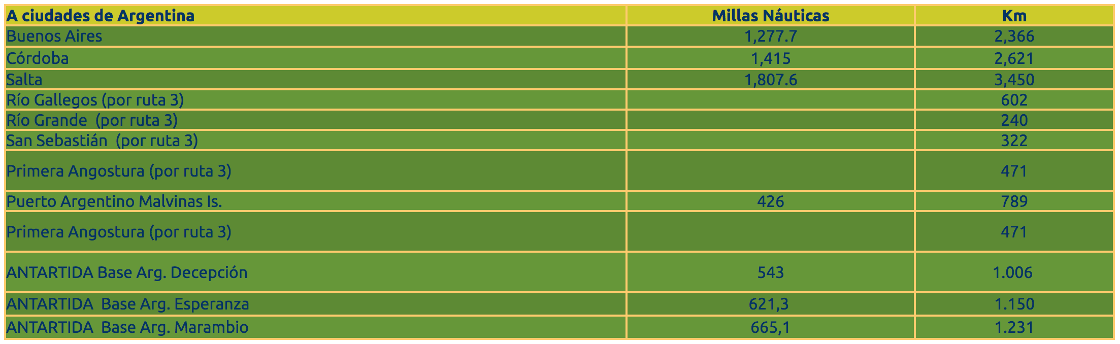
Emperor Penguin
(Aptenodytes forsteri)

King Penguin
(Aptenodytes Patagonicus)

Adelie penguin
(Pygoscelis adeliae)

Gentoo penguin
(Pygoscelis papúa)

Chinstrap penguin
(Pygoscelis antártica)
Rockhopper penguin
(Eudyptes chrysocome)

Macaroni Penguin
(Eudyptes chrysolophus)

Magellanic Penguin
(Spheniscus magellanicus)
WHAT IS THE ORIGIN OF THE PENGUINS?
Biologists classify all living things according to characteristics that allow different species to be grouped into higher-order groups. Among vertebrates, as well as humans we belong to the Order of Primates, penguins belong to the order Scientists recognize about 32 species of extinct penguins. Penguins probably evolved from flying birds more than 40 million years ago. As penguins' ancestors adapted to the marine environment, there were changes in their body structure for diving and swimming that resulted in the loss of adaptations for flying Sphenisciformes (pronouncing sphenisciformes), which encompasses all living penguins and extinct. To date, all penguin fossils have been found only in the southern hemisphere. Some ancestors would have reached up to 100 kg in weight. Scientists believe that the ancestors of the penguins began to share food resources in the sea with the marine mammals of that time, and that even more would have become their prey.
The living birds most closely related to penguins are albatrosses, petrels, and macans.
WHO SAW THE PENGUINS FOR THE FIRST TIME?
Practically all aboriginal groups that depended to a greater or lesser degree on coastal resources used penguins as a food resource. In Tierra del Fuego, it is known that the Magellanic Fuegian canoeists used penguins as a food resource for at least 6000 years ago. The first European explorers to see penguins were probably part of Bartholomeu Dias de Novaes' Portuguese expedition in 1487-88, rounding the Cape of Good Hope. The first documentation on penguin sightings corresponds to the Vasco da Gama expedition of 1497, when they described penguins observed on the southern coast of Africa. The discovery of the Magellanic penguin appears in the travel chronicles of Magellan in 1520.
WHY ARE THEY CALLED PENGUINS?
The name would refer to fat (penguigo in Spanish and pinguis in Latin) that penguins have. On the other hand, it is thought to derive from two Welsh words that mean "white head". The most widely accepted version is that penguin was used as the name for the now extinct "great alca", Pinguinus impennis (great auk), a flightless seabird from the northern hemisphere, similar to penguins and from which they would have received the name in the wrong way.

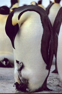
ROCKHOPPER PENGUIN
The rockhopper penguin owes its Castilian name to a group of long, yellow feathers located above its eye, like an eyebrow, which appear as a plume when the animal raises them. This plume is perhaps their most distinctive feature, along with the possession of strong nails on their legs, which allows them to climb steep slopes (which has earned them their English name: rockhopper). Furthermore, their nails are so strong that the successive passage of animals over the rocks leaves marks on the hard rocks of the island. The fins are black above and white with a characteristic black pattern that changes with age.
Like all penguins, it has adaptations to aquatic life, such as modified wings in fins, a highly hydrodynamic spindle-shaped body shape, and modified feathers imbricated in resemblance to the scales of a fish.
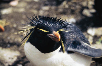
Sex can be differentiated by the size and shape of the beak. In the photo, on the left, an adult male. On the right, an adult female.
Its distribution is subantarctic. The chrysocome subspecies inhabits the southern tip of South America and the Malvinas Islands. The other two subspecies (mohoséele and fililí) are distributed in subantarctic islands.
THE ROCKHOPPER PENGUIN AND THE MODERN MAN
Probably the first modern sailors to touch the Malvinas Islands and the southern islands of South America began to use the Rockhopper penguins and their eggs. Wolfhounds and whalers used seabird eggs as a way to supplement their diet with fresh protein. Later they began to use penguins to make fat when wolves and cetaceans began to decline in numbers as a result of exploitation. Even during the 20th century, egg harvesting provided a source of fresh protein in the Malvinas Islands.
CURRENT CONSERVATION
During the 20th century, a notable numerical decrease has been documented in the populations of this species. In 1932/1933 3,169,000 nests were documented.
During 1995/1996, the existence of 297,000 nests was documented. The causes of this decline are unknown, although for other subspecies of the Rockhopper Penguin it has been postulated that the cause could be the modifications that have occurred in the ocean ecosystem as a result of the increase in its surface temperature. How a brief mention of penguins walking in a remote bay on the Isla de los Estados became one of the largest colonies of this species in the world. Until we began our work in the last decade, it was known that in Argentina the Rockhopper Penguin nests in two areas, broadly speaking.
The Malvinas Islands as a whole contain the largest number of colonies (36) and the largest number of nests recorded to date (297,000). Apart from the Malvinas, only Isla Pingüino, in front of Puerto Deseado, was mentioned as another colony (this one houses 250 couples).

From Isla de los Estados there were only vague historical references to the presence of colonies of Rockhopper penguins. Both the "Derrotero" published by the Naval Hydrography Service and "La Australia Argentina" by Roberto Payró (from 1898), indicated the existence of a colony of the Rockhopper penguin in Cabo San Juan. The only later reference is due to a botanist, Imshaug, who mentioned in 1972 that he observed the Rockhopper penguin nesting in the southeast corner of Franklin Bay. After that, in her book on the Isla de los Estados and prehistoric human occupation, the anthropologist Anne Chapman referred to the existence of "several colonies" in Franklin Bay.
Since 1992, we began to use, opportunistically, any boat or plane that could take us to that little-surveyed area of our geography, to carry out surveys of the coasts. Thus, we have the support of the Argentine Navy, the Argentine Naval Prefecture and the Government of the Province of Tierra del Fuego, to carry out flights or navigations to this difficult area.
In March 1994 we carried out a partial survey of the Isla de los Estados aboard the province's ARAVA plane. On that occasion, we managed to pass through Cabo San Juan and through Bahía Franklin. With surprise we discovered penguins among the dense grasslands of those coasts. The plane was traveling at 200 km / h, which made any attempt at identification difficult. The Imshaug and Chapman data appeared to be confirmed. We were able to return to the island in November 1995 and in January 1997, when we tried to make an extensive survey of the entire coast aboard an 11 m sailboat (Yagan III), with which we "caleteamos" practically 70% of the colony in Cabo de San Juan, not far from the mythical lighthouse of San Juan de Salvamento. Our next goal was to confirm Franklin Bay. However, despite spending a total of more than 50 days sailing around the island, Bahía Franklin refused us, as intense storms from the southwest forced us to seek refuge for several days in Puerto Poner. It was only in March 1998 that we were able to access Franklin Bay, during another expedition aboard the Fernández sailboat, on a day when a breeze was blowing from the east, which was ideal for our purposes of approaching Franklin Bay, open entirely to the southwest.
One morning, leaving Capitán Campea Bay, we decided to change our program on the fly and instead of going east along the south coast, we decided to turn and head towards the north coast, circling the west coast of the island. There was Franklin Bay. What we observed when we reached the bay shocked us. Along six linear km of coastline, the penguins were interspersed with the grasslands, sometimes in areas of bare ground of vegetation (sites of high concentration of nests) and sometimes between the stems of the tall grasslands.
The sites where these animals nest can be found both very close to sea level and on the steep slopes of the bay, 200 m high and more than 700 m from the coast. This means that for nests farthest from the sea, a penguin must spend more than an hour climbing up from the beach. We were at the end of the reproductive season, when the adults shed their plumage and then left the island and faced their winter migration. We arrived at Caleta Lacroix, where the Maritime Museum had been working on recovering evidence about the sinking of Luis Piedra Buena's ship, the Espora. If there was a place on the Isla de los Estados to go looking for penguins, that was without a doubt. Our predecessors, Imshaug and Chapman, had succeeded in locating the colony, but they did not even suspect what it represented in terms of the population residing there. As we leave Franklin Bay towards the island's coast, we pass two points (Punta Ruiz and Punta Vilca) located about three km northwest of Caleta Lacroix. There is another large part of this colony of Rockhopper Penguin, surely a detachment of this larger colony of Franklin Bay. In November 1998, we returned to Bahía Franklin to begin an ecological study of this species, thanks to the support of Total Austral and the logistical support of the Argentine Navy. The first thing we had to know was how many nests this colony housed. They seemed like a lot. However, the vastness of the colony made it difficult to think of how to survey such a large area.
Finally we made the decision to estimate the density of the nests that had eggs or chicks. This density value was going to tell us, on average, how many nests there were per unit area of 100 m2. After returning from the island, we made a flight with the Argentine Naval Prefecture, thanks to which we were able to obtain photos from the air of the colony. With these photos, we calculate the area of the places occupied with nests. Combining the data of the density of nests and the area of the colony, we obtained an estimate of the total number of nests.
In this way, we conclude that Franklin Bay is home to some 167,000 nests as a whole, some 50,000 nests more than the largest colony described for the Malvinas Islands. The second colony on Isla de los Estados, in Cabo San Juan, contained 7,000 nests. It is hard to believe that at the end of the 20th century the Franklin Bay colony was unknown to ornithologists. Despite this, this finding represents good news: the Rockhopper Penguin has recently been proposed as VULNERABLE by the International Union for Conservation of Nature (IUCN), due to the marked global reduction in its populations that it has suffered in the second half of the 20th century.
Bahía Franklin will count us as visitors again for years to come. We have many questions to solve, such as: In which areas of the Argentine platform are penguins feeding during the care of their chicks? Where do they go after the reproductive season? Does raising a chick in a nest involve the same effort? at sea level than in a nest 200 meters uphill ?; Do goats, red deer and rats have any effect on the development of the penguin colony? These are some of the questions that we propose to answer in the coming years, and with which we aim to answer a more general question about the conservation of this species: Where is the Rockhopper Penguin going?
WHAT IS THE LIFE OF A ROCKHOPPER PENGUIN LIKE?
The life of a Rockhopper Penguin is not easy at all, nor is it that of other species of birds in general.

Each species faces its own challenges related to the environment where it lives, the potential predators that may want to capture it, the ease or difficulty of finding food, to which must be added extraordinary and even catastrophic events such as an exceptional storm that may affect its young. or make it difficult for them to return to the colony.
To understand the life of a penguin we could start at birth, and progress through the stages of life until this animal produces its own offspring, which to some extent sums up the life cycle of a species. Last week of November. The time has come to be born. With the small nail that it has in its beak, it begins the breaking of the shell.
Just 20-24 hours after starting this process, the pigeon can leave the egg, weighing only about 60 grams. There may be a sibling in its nest, as the Rockhopper penguin lays an average of two eggs, although usually only the chick from the second egg (the largest) can survive the first few days.

During the first days, the father is the one who brings food for the chick, and the mother takes care of it, since being so small, this chick cannot regulate its body temperature and needs the protection of the parents. Upon reaching the colony, the father needs to relocate his nest. For this, he circulates among the other nests looking for his. However, the life of these penguins lacks a label.
Access to their own nest is plagued by pecks from other parents who do not accept this alien presence so close to their own nest. Once in its nest, the male performs vocalizations and a lateral movement with his head raised, thereby announcing his arrival and the mutual recognition between male and female. Without further ado, the male replaces the female in the nest and begins feeding the chick, regurgitating his food into the chick's small beak. Sometimes the dams provided by the parents are so large that they cannot be used and remain next to the nest. As the days go by, the chick grows rapidly, but pretends to continue to enjoy parental shelter. Obviously not all enter the nest. Around 20 days of age, the chicks begin to roam the colony alone, without staying in the nest and gather in groups called nursery (or créches).
The chicks have already grown up, they can exceed a kilo in weight and both parents need to go out to eat because the amount of food needed for the chick is increasing. Upon its return, the chick takes possession of the nest again for its parents to feed it. Parents feed on large areas of the platform and slope. However, the commitment to return to feed their chick restricts the birds not to stray too far from the Isla de los Estados.
In the future we hope to be able to learn about these trips by installing sensors that record the geographic position of the animals at precise intervals. Getting in and out of the colony is not easy. In general, this species nests in colonies exposed to the prevailing swells and winds. Leaving the colony to feed means waiting on the shore for a great wave to literally "wash" the penguins from the rock they are waiting on. Returning is not an easy task either.
In general, the small herds of up to 15 animals return that in a line proceed to climb the rocks of the coast as a wave rises over the rocks. However, the last animals in line may find that the wave that facilitated the exit of the first in line is returning, so they cannot get out and fall back into the sea. At that precise moment they are vulnerable to attacks from the fur sea lion that pounces on the last in line. The wolf captures an animal with its mouth, shakes it to break its spine, like something from the visors and chest, and leaves the rest to go in search of another individual. The giant petrels go in search of the rest.
The station continues its unfolding with the adults bringing food to the pigeon approximately once a day. Around 40 days of life, the chick begins to shed its down to acquire its first juvenile plumage. Towards the end of January, after completing the molt, the now juveniles leave the colony with the rest of the adults in large groups that go to feed. The adults will return in a few days to change their plumage to face autumn and winter at sea.

Molting is a really traumatic process for these birds. To understand this, it must be thought that all the new feathers that replace the old ones are generated from the transformation of the penguin's own body tissues into feathers. During the molting process, these animals can lose up to 50% of their weight. They arrive at the pre-winter molt with about 4 or 5 kg of weight. Without further parental responsibilities, the adults with their renewed plumage leave the colony to carry out their winter migration. They will be at sea for the next six months.
Little is known about their migratory routes. The most recent data comes from the Malvinas Islands, where English researchers are placing transitors on the back of penguins to follow them on their foraging journeys. From what is known to date, their migration areas are very extensive, being able to reach from the Malvinas to off the coast of Tierra del Fuego, or to Puerto Deseado, and they still leave the waters of the platform to enter towards the east. in the Atlantic Ocean. At the beginning of October the males will return to the breeding colonies. The females will do it about two weeks later. The laying of eggs will occur at the end of October, and after 33 days of incubation, the new chicks will be born. The juveniles will not return until two to three years later, although some of them can occasionally be seen in the colonies during the breeding season.