ISLA DE LOS ESTADOS

Flora

Postal Service History

Luis Piedra Buena

Shipwrecks
At the eastern end of the Isla Grande de Tierra del Fuego and separated by 30 kilometers of water, a passage known as the Strait of Le Maire, the last foothills of the Andes Mountains emerge from the icy waters.
Mountainous in appearance, with sharp and steep peaks, it is 65 kilometers long and its width varies from 16 kilometers to 500 meters. More than 120 fresh water mirrors give rise to small streams and waterfalls of crystalline waters.
The south side of the island presents a desolate and terrifying aspect, being the least frequented. It is the side most affected by the storms and winds that from the South Pole find this island as their only obstacle in their race to the north. With strong currents, stormy seas, poor visibility and sudden calms, dozens of large sailboats disappeared in the vicinity. Until the opening of the Panama Canal, the region was crossed by thousands of ships on their way to Australia, Asia or the west coast of the United States.

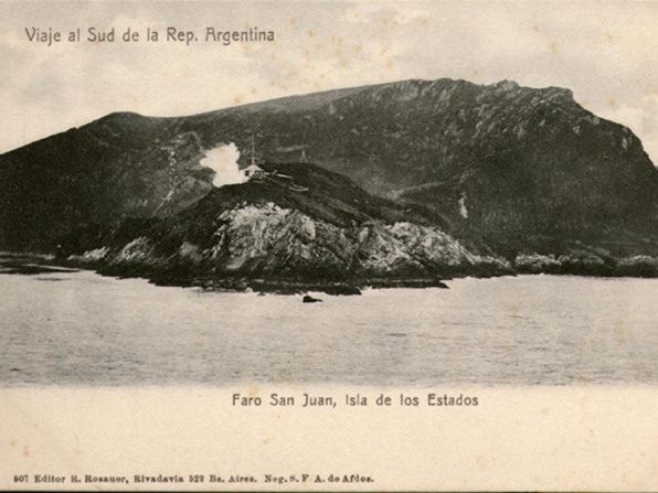
On the inhospitable Island of the States, a place swept by the wind and rains, on May 25, 1884. The Expedition to the South Atlantic commanded by Don Augusto Lasserre, builds the San Juan de Salvamento Lighthouse and a Rescue Station which would become a Subprefecture.

France donated a lighthouse similar to the one that existed in San Juan de Salvamento and it was placed, in 1998, in the same place where the first was. Again the light that indicated the entrance to the port came on, only that solar panels and an electronic system have replaced the rapeseed oil and the 6 men in charge of its custody.
ISLA OBSERVATORIO
On October 1, 1902, the light of the New Year's Lighthouse was lit for the first time. This replaced the Lighthouse of San Juan de Salvamento.


Only the constructions of the lighthouse keeper house remain of what was a group of buildings where the Magnetic Observatory that was built in 1917 operated. before leaving for the unknown.

The San Juan de Salvamento Cemetery, at the end of the port, still preserves some crosses of several dead prisoners. At the end of 800 the place was chosen as a Military Prison. The tombs of the Indians were on the opposite side and did not bear crosses The Maritime Museum of Ushuaia, together with the Ice Lady Patagonia team of the brothers, worked on cleaning and placing new crosses on the graves

PORT COOK
The Argentine Navy maintains several boathouses that serve as moorings in various ports on the Island and Tierra del Fuego. The work is supervised by divers to verify its fixation to the seabed. Port Cook, on the north side of the island, is separated from Port Vancouver, on the south side, only by a narrow isthmus that is 500 meters wide. Although the distance is short, the step is heavy due to the peat bogs that exist in it. Long ago this isthmus was used by fishermen and wolf hunters to carry their boats from one side of the island to the other. In this way they could leave the ship in safe waters and with smaller boats risk the rocks where the sea lions were. In Port Cook was the Military Prison that was transferred from San Juan de Salvamento in 1899 for humanitarian reasons.

Only this cemetery remains of him, inaugurated in January 1900, which in addition to being prisoners has the graves of many shipwrecked people who were found in the vicinity, such as those of Ana de Hamburgo.
Near the cemetery and a little further east we find the remains of the "mythical" Eyroa square. This was built by Don Luis Piedra Buena and, in addition to being a refuge for his men, it was used by the castaways while they tried to reach San Juan de Salvamento, or were waiting for someone to pass through the area. Until 1960 it was kept with food. This material construction is the almost only remains of the Military Prison that functioned in Port Cook between 1899 and 1902. Apparently it was the local police station since the rest of the buildings were made of wood and corrugated sheet metal that were later transferred to Golondrina Bay in Ushuaia. Another vestige of these constructions are the sticks nailed in the beach where a footbridge passed.
At the time of the closure and transfer of the prisoners to Ushuaia, there was a violent riot that divided the prisoners into three groups. Those who did not want to riot, the violent ones who murdered and those who were against it. The search took several months until all the men were found. Most gave themselves up voluntarily, but there was a group that managed to cross the Strait of Le Maire and were found wandering along the coast. They were transferred to Buenos Aires where they were tried and the leaders were sentenced to the death penalty.


FRANKLYN BAY
With the support of the Argentine Navy we have been looking for several years for the place where Don Luis Piedra Buena lost the "Espora" and built the legendary "Luisito". So we went around the island and on an expedition with Jorge Trabuchi's Callas sailboat we found a place that matched Don Luis's description. In this way we return to search with more time. Among the work guides we had the diary that he wrote during his forced stay of 3 months in the place. We were able to interpret the place and in that way we found the remains of the hull that fortunately the sea was in charge of unearthing and many remains of wood; to the mainmast of this Schooner Brig. The wood was analyzed and matches the wood used for construction at that time in the northern hemisphere.

The former "Nancy" from the United States had been located. But the search continued and thus the chain appeared and even the rock where he relates that he tied the chain in an attempt to save his beloved ship. At the same time and with wood from the area plus the one he had on board, he built an 11-meter-long cutter. The escobenes, remains of the cover and bottles of liquor appeared. All scattered around this great beach where each tide covers it almost in its entirety. With a very low gradient, it fully coincides with Don Luis's descriptions when he recounts how difficult it was to carry the cutter until it floated. The storms and the force of the sea did the rest; This bay, open to the southwest, receives the onslaught of the waves with unusual force.
Climbing the side of the hills we find the forest of the "curvones". This was provided to make the frames of the new ship; Nature made tree trunks curve in the most varied ways. The famous bay of otters, as Don Luis called it. Two rivers flow into it where we could observe otters or river wolves. The reason why he navigated the area was to exploit a natural resource that was considered inexhaustible: hunting sea lions and penguins to take advantage of their fat that was used for lighting. This activity was complementary to whaling. These Rockhopper penguins are the ones that Don Luis Piedra Buena and his men would hunt. They put them in a "can" and cooking them extracted the oil.
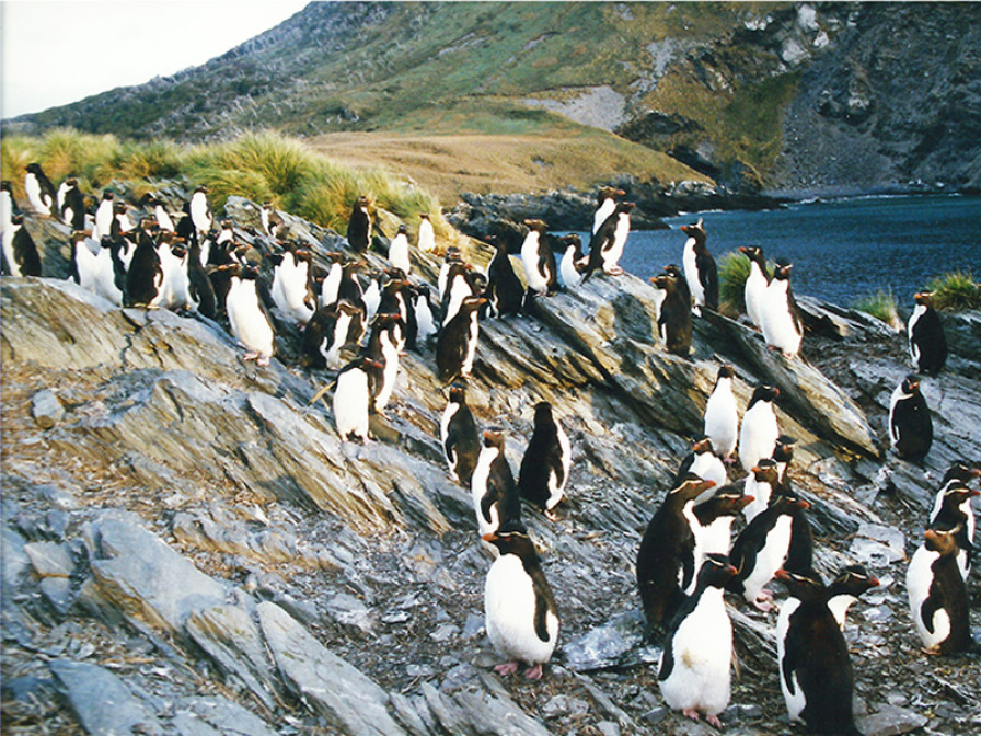
At present they are the object of study since until 1997 the existence of such a large colony was unknown. Scientists in different campaigns carry out a survey of the number of nests, feeding habits, weight, development and are currently studying their migratory and fishing habits. With special sensors they know how deep they are submerging and where they are moving. But Franklyn Bay brought us many more surprises like finding a large pilot dolphin stranding. But the surprises continued. About 30 meters from the remains of the Espora, and in the forest, right next to a stream, as described in his diary, we find the remains of a construction. In it we find a saw arch, cables, blocks, bottles and corrugated sheets of what was the roof and lead sheet of which was used for the bottom of the ships. Obviously it was the refuge and warehouse that Don Luis built next to the improvised shipyard. Don Luis Piedra Buena traveled these difficult seas that included, in addition to the Isla de los Estados, Cape Horn itself, the Strait of Magellan and the coast of Santa Cruz. For almost 2 decades he was the only one to carry an Argentine flag. He even had to arm his schooner with 3 small cannons to face the North American and English wolfhounds. The entire region was highly valued for the large number of whales, sea lions and penguins. The Malvinas Islands were the base of many of these Anglo-Saxon wolfhounds who had the Argentine south as a source of wealth. This is how in 1859, on Pavón Island, on the Santa Cruz River, he built his warehouse and house with a stockade for the protection of the Indians, and established the first Colony in the Argentine South. Our idea was to see if we could find remains similar to those found in Franklyn Bay in the vicinity. We were able to verify that the remains of plates and nautical elements were of the same origin as well as the handmade bottles.
Inside the recreated house there is today a small Site Museum. In it it is possible to find belongings of the ancient settlers; hides, stuffed fauna specimens; utensils of daily life and various artifacts used in the field. All that mixed with projectile points, boleadoras and axes used by the Tehuelches. Also many elements of nautical use, similar to those found in Isla de los Estados. The remains of the settlement of Gregorio Ibañez would have been located where the tiles are. The date could be from 1868 onwards and there to the west at 2000 meters is the old cemetery where the remains of Gregorio Ibañez are deposited, who was the first pilot of Piedra Buena and who is considered the first inhabitant of Comandante Piedra Buena. , because Gregorio Ibañez later moved from this point where he had settled to the west also to the bank of the river about 15 km from here, and there he settled permanently with his family in a field of a league that the government granted him for the decree of January 25, 1880.
In that property, let's say, the town of Comandante Luis Piedra Buena was later established, that is why Ibañez considers him the first inhabitant of the place. In front of the south coast we have what is known by the name called by Moyano as the Zanjón de las Salinas, which Piedra Buena exploited there in 1868, and there he had some ranches where his people lived, the people who exploited the salt flats. In this place that Moyano called the Rincón de las Salinas, Piedra Buena arrived with his boat to that place, that is, I suppose that perhaps he did not advance much further upriver, but that this was the point where he arrived with their boat and from there they went to Pavón Island on horseback or by boat. A sunny day on Isla de los Estados is rare. These images make us think of an island in the Caribbean but the green vegetation is given by being the last sub-Antarctic forest. Further south the vegetation dies out. The island has a maritime climate, depending directly on the sea that surrounds it. The annual average temperature varies from 0 to 5º C, this tells us about a constant fresh average temperature. The average of strong storms is 73 days a year. Very humid region, with almost daily rainfall, with an average of 248 days a year. It is normal to see it covered with clouds. Driven by the winds from Cape Horn, they are trapped by the high hills that cover the entire island, even though the sun is shining around them. This same wind is the one that is tearing them to shreds and thus the island appears and disappears before the eyes of the sailors who tried to see beyond the clouds and find where to pass.
PORT PARRY
In the eastern half of the Island we find deep fjords that are protected natural harbors. Port Parry, as this long fjord is called, about 7 kilometers long and with depths reaching 100 meters, is surrounded by hills that climb up to 600 meters in altitude. Among the legends of the region there is an account that on this coast the Russian anarchist Ivanitzky was found dead, escaping twice from the Port Cook Military Prison. Many did it to feel free for a while, since in a short time, they gave themselves up.
The island, as a jail, turned out to be an impregnable bastion. But their prisons were lifted due to the rigors of the climate and because they were considered inhumane, both for the prisoners and for the jailers. Even so, many of them came with their wives, as in the case of soldier Valentín Rivera and his wife from San Nicolás, Ana Echegaray, with a 3-year-old boy. At the bottom of the fjord is the Don Luis Piedra Buena Naval Station.
Since December 1978, a group of 4 or 5 men from the Argentine Navy has been rotating every 45 days of permanence. During that time they are busy with maintenance and repairs when they do not undertake new work such as improving the pier, the trails or the intake of water in the waterfall. During that period they are united with the Ushuaia Naval Base only radially. The Island of the States was used by sailors of all times.
San Juan de Salvamento, known as Saint John or Saint Jean, appeared in all nautical routes as a good place for repairs, with abundant drinking water, wood, wild celery to combat scurvy and fresh meat from penguin and sea lion. From the Malvinas they came in search of firewood and wood for the buildings. Don Luis Vernet, the first Argentine governor of the Falklands, had a sawmill in Basill Hall. His sketches of the Island include the years 1828, 29 and 30 with hunting excursions for sea lions. In order to confuse the competitors, these spotlights changed the name of the geographical features and Cape Buen Suceso had it renamed Cape Horn.
Likewise, Don Luis Piedra Buena called Bahía de las Nutrias, we suppose Caleta Lacroix or Córdoba. An ascent to the hills that surround the Piedra Buena Naval Station gives us a good idea of the place. The vegetation changes as we ascend. While on the coast the sour cherry trees have a straight and thick trunk, as we climb the trees they become stunted shrubs. We can say that the flora of the place is the same as in the rest of Tierra del Fuego, but among the larger plants the sour cherry predominates and not the lenga as in the Big Island.
Another characteristic is that there are almost no exotic plants to the place. The work was carried out in several campaigns by Fernando Biganzoli, from the Darwinion Institute in Buenos Aires. Already after 350 meters we only find the odd bush, lichens and mosses. These require a lot of humidity which is easy to find on the island. The ground is largely covered by peat and this makes for quite a slippery climb. From these ponds of rainwater and meltwater, hoses run down that feed the deposit of the colony and the ships can also be resupplied. The streams that flow into the sea usually have yellowish waters. This is due to its passage through the peat that gives it an acid PH, although it is still drinkable. Back at the Naval station, you cannot stop thinking about this handful of men who exercise sovereignty over the place on an island that was coveted by other nations.
They tried to buy half of the island from Don Luis Piedra Buena, and after he lost almost all his material goods as a result of his shipwreck, for 10,000 pounds, to which he refused. Its wealth in wood was coveted by the English who settled in the Malvinas. The Island was owned by Luis Piedra Buena until the National government bought it back from his heirs in 1912. His name was always closely linked to that of the Island and this is how on August 10, when another anniversary of his death, the Day of the Island of the States is also celebrated. Every day, very south of the continent and a few kilometers from Antarctica, meteorological data for the safety of fishing boats and ships passing through the area are transmitted from the Comandante Luis Piedra Buena Naval Station. His presence is still in the atmosphere, as when more than a century ago, putting aside his commercial interests, he dedicated himself to rescuing shipwrecked people from certain death in these icy waters and inhospitable lands. This is how he received the nickname "Knight of the Sea".